VANCOUVER, BC, April 12, 2018 – Silver One Resource Inc. (TSX-V: SVE; FSE: BRK1; OTC: SLVRF – “Silver One” or the “Company”) is pleased to announce results of the geophysical survey conducted on its wholly-owned Peñasco Quemado silver property in Sonora, Mexico.
Four main controlled-source audio-frequency magnetotellurics (“CSAMT”) low resistivity anomalies have been delineated, which significantly expand the exploration potential outside the historic resource area previously outlined by Micon International for Silvermex Resources Ltd. in 2006. This drill-defined historic resource identified 9.6 million ounces of silver at an average grade of 117 gm/t silver contained within a shallow, westward-dipping, near-surface manganese-oxide silver replacement horizon. Two of the four target areas are encompassed by strong zinc (values to 3,500 ppm Zn), lead (values to 800 ppm Pb), and copper (values to 1,200 ppm Cu) with barium, manganese, and moderate silver geochemical anomalies (see Company news release dated March 1, 2017). Two additional geophysical anomalies are associated with medium level geochemical anomalies. These four target areas can be seen superimposed on the zinc soil geochemistry map on the Company website www.silverone.com. Additionally, a map showing the outline of the geophysical grids can be viewed on the website.
Greg Crowe, Silver One’s President and CEO commented, “This geophysical survey has been very successful in identifying potential for down-dip, westward extensions to the historic resource area that have never been drilled. It has also outlined new areas of low resistivity that are associated with strong to moderate zinc, lead and/or copper in soil geochemical signatures. The CSAMT further identified deep zones of low resistivity which suggest wide channelways for potential mineralizing solutions. The silver manganese oxide resource area, in combination with the zinc-lead-silver system as identified in the soils geochemistry, have geological similarities to the Hermosa-Taylor deposits being developed by Arizona Mining, located approximately 125 kilometres to the northeast of Peñasco Quemado.”
The first anomaly, Target 1, is a 1,000 metre long x 500 metre wide, northeast-southwest oriented zone characterized by low resistivities (13-90 ohm-m). This potentially represents the down-dip continuation of the Peñasco Quemado replacement manto (occurring within a conglomerate horizon) that hosts the historic mineral resource outlined in 2006.
Target 2 is also a low resistivity zone (20 – 120 ohm-m) that is coincidental with highly anomalous soil geochemistry in the western portion of the property. The three-dimensional (“3D”) geophysical signature suggests the anomaly extends to depths greater than 400 metres.
Target 3 is a low resistivity area that is associated with moderately elevated geochemistry. It is anomalous in that it is an area underlain by granite, which should yield a high resistivity signature. The interpretation is that the low resistivity is represented by something other than unaltered granite at depth.
Target 4 lies just to the east of the very strong zinc-lead geochemical signature that occurs along strike to the southeast of the historic resource associated with the Penasco Quemado replacement manto. It too is characterized by low resistivity and appears to continue to depths greater than 300 metres.
Figure 1: Zinc Soil Geochemistry & CSAMT Targets
Figure 2: Geophysics CSAMT – Grid and Resistivity Low Anomalies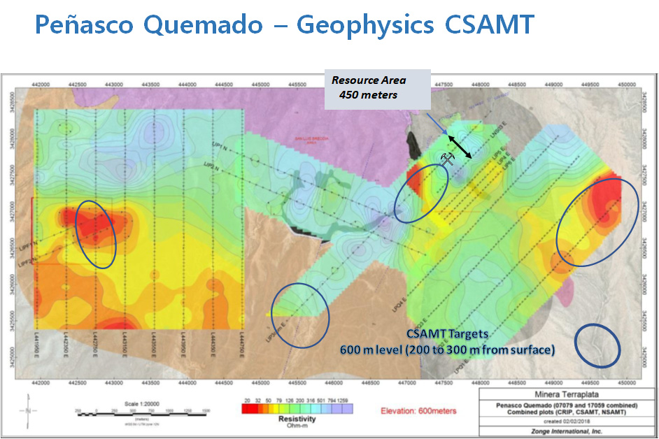
Geophysical Survey
The geophysical work consisted of a 36-kilometre CSAMT survey completed in December 2017, which was integrated with data of a 14-kilometre induced polarization (“IP”), complex resistivity (“CRIP”) and natural source audio magnetotellurics (“NSAMT”) survey done in 2007. Zonge International, a well-respected geophysical services company, conducted both surveys. In addition, they consolidated and reinterpreted the 2007 geophysical data and completed new petrophysical testing in drill core samples performed concurrently with the CSAMT survey.
The new CSAMT survey was separated into two areas called Western Area (8 lines) and Eastern (4 lines), each line being three kilometres in length. The lines traversed strong soil geochemical zinc, lead, copper, manganese and barium anomalies.
The 2007 survey consisted of nine lines of variable length which covered mainly the resource area as well as surficial geological targets located in the central part of the property, over areas devoid of anomalous geochemical values. The 2007 survey also included two IP lines over the La Fortuna area, located in the western side of the property. La Fortuna occurs in the westernmost portion of the soil geochemical anomalies of the Western Area.
Qualified Person
The technical content of this news release has been reviewed and approved by Greg Crowe, P. Geo, President and CEO of Silver One, and a Qualified Person as defined by National Instrument 43-101.
About Peñasco Quemado
Peñasco Quemado is a 3,746-hectare property located in northern Sonora, 60 kilometres south of the town of Sasabe on the US-Mexico border. A 2006 drilling program outlined a historical measured and indicated resource of 2.57 million tonnes at a grade of 117 g/t silver for a silver historic measured and indicated resource of 9.63 million ounces. The silver mineralization is associated with manganese and barium oxides in a near surface shallow westerly dipping zone of volcaniclastic rocks formerly called polymictic conglomerate.
Silvermex Resources Limited reported in a technical report titled “Updated NI 43-101 Technical Report and Resource Estimate for the Penasco Quemado Silver Property” dated March 9, 2007 (filed on SEDAR on March 16, 2007), prepared by William J. Lewis and James A. McCrea, the above referenced historical mineral resource estimate. The historical mineral resource estimate used “measured mineral resource”, “indicated mineral resource” and “inferred mineral resource”, which are categories set out in NI 43-101. Accordingly, Silver One considers these historical estimates reliable as well as relevant as it represents a target for exploration work by Silver One. The historical resource estimate is set out in detail below:
RESOURCE CATEGORY | MINERAL TYPE | TONNES | AG | AG |
|---|---|---|---|---|
Measured | Oxides | 0.12 | 152 | 0.60 |
Indicated | Oxides | 2.44 | 115 | 9.03 |
Total M + I | Oxides | 2.57 | 117 | 9.63 |
Inferred | Oxides | 0.10 | 41 | 0.13 |
** The data base for the historical resource estimate consisted of 24 reverse circulation holes from a 1981/82 program, 17 reverse circulation holes from a 2006 program and 8 diamond drill holes from a 2006 drill program. Assay data was available for all 49 of the drill holes and 12 trenches. The mineral resource estimate used a kriging estimation method to establish ore zones with a cut-off grade of 30 g/t Ag and assay’s capped at 700 g/t Ag. Resource blocks were estimated by ordinary kriging with samples within a search radius of 25 meters classified as a measured mineral resource, within 47 meters classified as an indicated mineral resource and within 70 meters classified as an inferred mineral resource. As required by NI 43-101, CIM definitions (August 2004) were used to classify mineral resources with the classification of each kriged ore block dependent upon the number of penetrating holes. An in-situ block density of 2.50 t/cu meter was assigned the ore blocks. The qualified person has not done sufficient work to classify the historical estimate as a current mineral resource. Silver One is not treating this historical estimates as current mineral resources.
About Silver One
Silver One is a silver focused exploration company that holds an option to acquire a 100% interest in the past producing Candelaria Silver Project, located in Nevada, from SSR Mining Inc. (formerly, Silver Standard Resources Inc.) and holds a 100% interest in three significant silver assets located in Mexico: Penasco Quemado in the State of Sonora, La Frazada in the State of Nayarit, and Pluton in the State of Durango. The mining assets located in Mexico were acquired from First Mining Gold, which became a key shareholder resulting from the transaction.
For more information, please contact:
Silver One Resources Inc.
Monica Hamm
VP, Investor Relations
Phone: (604) 974?5274
Email: [email protected]
Forward-Looking Statements
Information set forth in this news release contains forward-looking statements that are based on assumptions as of the date of this news release. These statements reflect management’s current estimates, beliefs, intentions and expectations. They are not guarantees of future performance. Silver One cautions that all forward looking statements are inherently uncertain and that actualperformance may be affected by a number of material factors, many of which are beyond Silver One’s control. Such factors include, among other things: risks and uncertainties relating to Silver One’s limited operating history, ability to obtain sufficient financing to carry out its exploration and development objectives on its mineral projects, obtaining the necessary permits to carry out its activities and the need to comply with environmental and governmental regulations. Accordingly, actual and future events, conditions and results may differ materially from the estimates, beliefs, intentions and expectations expressed or implied in the forward-looking information. Except as required under applicable securities legislation, Silver One undertakes no obligation to publicly update or revise forward-looking information.
NEITHER TSX VENTURE EXCHANGE NOR ITS REGULATION SERVICES PROVIDER (AS THAT TERM IS DEFINED IN THE POLICIES OF THE TSX VENTURE EXCHANGE) ACCEPTS RESPONSIBILITYFOR THE ADEQUACY OR ACCURACY OF THIS RELEASE.
Original Article: https://www.silverone.com/news/2018/new-exploration-targets-identified-by-geophysics-at-silver-ones-penasco-quemado-property-sonora-state-mexico/


