TORONTO, ONTARIO–(Marketwire – March 4, 2013) – Mammoth Resources Corp. (TSX VENTURE:MTH) is pleased to report that it has received additional assay results from samples taken from its geological team exploring the company’s Tenoriba Property, located in the prolific Sierra Madre precious metal belt in south western Chihuahua State, Mexico (refer to the company’s web site www.mammothresources.ca, for a detailed location map). The best result from this most recent campaign, the third campaign mapping and sampling surface outcrops and structures on the property, assayed 9.4 grams per tonne (gpt) gold and 15.7 gpt silver, or 9.7 gpt gold equivalent (using a ratio of 50 gpt silver is equivalent to 1.0 gpt gold based on current gold and silver prices) from a grab sample located within the Moreno prospect on the property. This single highest gold assay was followed by 31 other samples that exceeded more than 3.0 gpt gold equivalent (refer to Table 1. Surface Outcrop Samples for complete assay results assaying greater than 0.3 gpt gold equivalent).
Mammoth President and CEO Thomas Atkins commented on these results, stating: “We continue to encounter anomalous gold and silver results over various target areas, including Los Carneritos, el Moreno and the area previously drilled by the former optioning party Masuparia Gold wherein they intersected 42.9 grams per tonne gold over a 1.9 metre intersection of a 15 hole diamond drill program completed in 2008. These areas plus several others, cover an overall area of at least 15 square kilometres. Clay X-Ray Diffraction analysis together with mineral assemblage and the type of rocks observed appear at this time to indicate a high-sulphidation target at Tenoriba. The gold and silver values reported in this press release continue to expand these areas of mineralization, numerous of which remain open. We continue to map and sample extensions to these areas and additional areas on the property, such mapping and sampling of which to date has covered only 20 percent of the total 8,100 hectares of the property.”
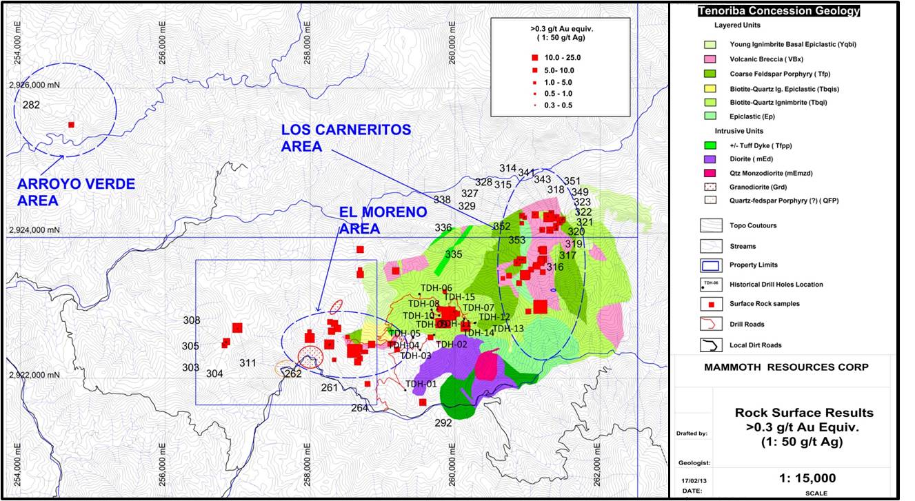
As previously reported (press release dated January 18, 2013), at Los Carneritos, El Moreno and within the area drilled by the previous optioning party (Masuparia Gold – 2008 drill program) (refer to Figure 1. Sample Location Map, Tenoriba Property, Chihuahua, Mexico) discreet structural and possibly lithological mineralization controls have been identified along steeply dipping, near vertical northeast, northwest and near north-south trending structures and near flat lying volcanic breccias. The discreet structural controls generally exhibit moderate to strong silica alteration with or without sulphide (most commonly pyrite) and with frequent patchy vuggy silica texture.
Ongoing mapping and sampling at Los Carneritos, has indicated that the dominant and discreet sub-vertical to moderately dipping structures controlling the mineralization and alteration are north-northeast and northwest trending with northeast and west-northwest structures also present in a lesser amount. The silica alteration and presence of vuggy silica is overall greater in Los Carneritos then elsewhere on the property as are anomalous (greater than 0.1 gpt gold equivalent) values of gold and silver. Of the 111 samples taken to date at Los Carneritos, 89 percent have returned values greater than 0.1 g/t gold equivalent and 69 percent greater than 0.3 g/t gold equivalent. Presently the size of the Los Carneritos target area is approximately 1.4 kilometres by 0.7 kilometres and it remains open toward the south and north.
At El Moreno the dominant discreet steeply to moderately dipping structures controlling the mineralization and alteration are southwest and northwest with minor west-northwest and north-northeast structures also present. In this area, compared with Los Carneritos, the silicification is generally a bit less intense and the vuggy silica texture is generally patchy and less abundant. El Moreno target area covers approximately an area of 0.7 kilometres by 0.5 kilometres.
Over Masuparia’s historical drilled area very little additional work has been performed although recent work identified less silica alteration in this area, it being patchier than at Los Carneritos and El Moreno areas. In all three areas moderate to strong clay alteration is present.
Recently, at Arroyo Verde area reconnaissance mapping and XRD sampling has identified the presence of dickite and kaolinite and opaline silica in a large (greater than 2.0 square kilometres) highly altered volcanic breccia. Only two samples of the 14 taken to date have returned anomalous results (greater than 0.1 g/t gold), the best being sample 330282 which assayed 0.4 g/t gold and 24.7 g/t silver. In addition small outcrops of highly silicified and patchy vuggy silica were observed in the southern part of Arroyo Verde. Three samples (330283 – 330285) from these outcrops failed to return anomalous gold or silver values. Although samples 330283 and 330284 returned high arsenic values respectively (1,925 and 3,250 parts per million). These high arsenic values are encouraging since they could indicate that gold-silver mineralization could exist at depth. In addition dickite was identified along a clay filled fracture in sample 330283. Further work is planned in the near future over this area.
The La Verde, Cerro Colorado and Rincon Colorado areas within the property also have returned anomalous surface sample results that need further investigation.
About Mammoth Resources:
Mammoth Resources (TSX VENTURE:MTH) is a mineral exploration company focused on acquiring and defining precious metal resources in Mexico and other attractive mining friendly jurisdictions in the Americas. The Company has an option to acquire 100% of the Urique Property and the Tenoriba Property located in the Sierra Madre Precious Metal Belt in southwestern Chihuahua State, Mexico and continues to seek other option agreements on other properties it deems to host above average potential for economic concentrations of precious metals mineralization.
Qualified Person / Quality Controls:
Richard Simpson, P.Geo., Vice-President Exploration for Mammoth Resources Corp. is Mammoth’s Qualified Person, according to National Instrument 43-101, for the Tenoriba property and is responsible for any technical data mentioned in this news release. Samples were prepared and analyzed by ALS CHEMEX in their facilities in Mexico and Canada, respectively. Samples generally consisted of 1-3 kg of material. Gold analyses were performed by 30 gram fire assay with an AA finish. Silver, copper, lead and zinc were analyzed as part of a multi-element ICP package using an aqua regia digestion.
To find out more about Mammoth Resources and to sign up to receive future press releases, please visit the company’s website at www.mammothresources.ca.
Forward-Looking Information: This news release may contain or refer to forward-looking information. All information other than statements of historical fact that address activities, events or developments that the Company believes, expects or anticipates will or may occur in the future are forward-looking statements; examples include the listing of its shares on a stock exchange and establishing mineral resources. These forward-looking statements are subject to a variety of risks and uncertainties beyond the Company’s ability to control or predict that may cause actual events or results to differ materially from those discussed in such forward-looking statements. Any forward-looking statement speaks only as of the date on which it is made and, except as may be required by applicable securities laws, the Company disclaims any intent or obligation to update any forward-looking statement, whether as a result of new information, future events or results or otherwise. Although the Company believes that the assumptions inherent in the forward-looking statements are reasonable, forward-looking statements are not guarantees of future performance and, accordingly, undue reliance should not be placed on these forward-looking statements due to the inherent uncertainty therein.
| Table 1. Surface Outcrop Samples (Gold Equivalent) | ||||||||||
| Sample Number | Sample Width | Sample Type | Gold | Silver | Gold Equivalent | |||||
| (grams/tonne) | (grams/tonne) | (grams/tonne) | ||||||||
| 330328 | 1.0 | chip | 0.318 | 1.40 | 0.346 | |||||
| 330318 | 1.5 | chip | 0.336 | 0.80 | 0.352 | |||||
| 330264 | grab | 0.158 | 11.30 | 0.384 | ||||||
| 330304 | 1.0 | chip | 0.107 | 15.50 | 0.417 | |||||
| 330322 | 1.0 | chip | 0.259 | 9.30 | 0.445 | |||||
| 330319 | 1.5 | chip | 0.309 | 7.40 | 0.457 | |||||
| 330316 | 1.5 | chip | 0.320 | 7.20 | 0.464 | |||||
| 330321 | 1.0 | chip | 0.331 | 7.40 | 0.479 | |||||
| 330329 | 1.0 | chip | 0.477 | 0.70 | 0.491 | |||||
| 330341 | 1.0 | chip | 0.323 | 8.90 | 0.501 | |||||
| 330317 | 1.5 | chip | 0.510 | 1.00 | 0.530 | |||||
| 330323 | 1.0 | chip | 0.309 | 11.30 | 0.535 | |||||
| 330352 | 1.0 | chip | 0.106 | 22.40 | 0.554 | |||||
| 330327 | 1.0 | chip | 0.520 | 2.40 | 0.568 | |||||
| 330308 | 1.5 | chip | 0.539 | 1.50 | 0.569 | |||||
| 330320 | 1.0 | chip | 0.430 | 9.40 | 0.618 | |||||
| 330349 | 1.0 | chip | 0.446 | 9.00 | 0.626 | |||||
| 330351 | 1.0 | chip | 0.067 | 37.80 | 0.823 | |||||
| 330282 | grab | 0.394 | 24.70 | 0.888 | ||||||
| 330303 | 1.0 | chip | 0.449 | 24.40 | 0.937 | |||||
| 330335 | 1.0 | chip | 0.687 | 18.10 | 1.049 | |||||
| 330315 | grab | 0.989 | 16.20 | 1.313 | ||||||
| 330292 | grab | 0.981 | 17.40 | 1.329 | ||||||
| 330353 | 1.0 | chip | 1.290 | 5.40 | 1.398 | |||||
| 330305 | 1.5 | chip | 0.790 | 48.80 | 1.766 | |||||
| 330338 | 1.0 | chip | 0.877 | 66.60 | 2.209 | |||||
| 330336 | 1.0 | chip | 1.565 | 90.70 | 3.379 | |||||
| 330343 | 1.0 | chip | 3.850 | 11.80 | 4.086 | |||||
| 330262 | grab | 3.120 | 68.10 | 4.482 | ||||||
| 330314 | grab | 4.430 | 32.50 | 5.080 | ||||||
| 330311 | grab | 0.673 | 263.00 | 5.933 | ||||||
| 330261 | grab | 9.390 | 15.70 | 9.704 | ||||||
To view “Figure 1 – Sample Location Map, Tenoriba Property, Chihuahua, Mexico (330 series of samples)”, please visit the following link: http://media3.marketwire.com/docs/Figure3MammothResources.jpg.
Neither the TSX Venture Exchange nor its Regulation Services Provider (as that term is defined in the policies of the TSX Venture Exchange) accepts responsibility for the adequacy or accuracy of this release.


