Vancouver, Canada, Aug. 24, 2022 (GLOBE NEWSWIRE) — Oroco Resource Corp. (TSX-V: OCO, OTC: ORRCF) (“Oroco” or “the Company”) is pleased to announce assay results from an additional 3,050 m of drilling from holes N015 through N018 of its drilling program in the North Zone of its Santo Tomas property (the “Property”) in northwestern Mexico (see Table 1 below and Figure 1 attached, or at the Company’s website.
The program is proceeding well with the results continuing to confirm and expand the 2009 Gradeshell model of Cu > 0.30% (the “Gradeshell”) derived from the historical drilling described in the Company’s 2019 Technical Report.
A total of 26 holes (18,136 m of drilling) have now been completed in the North Zone, spanning 1,100 m of strike length, with intersections of good grade mineralization returned in all holes for which the Company has received assays.
HIGHLIGHTS:
- Hole N015 bisected the Gradeshell (extending above and below the Gradeshell), returning a 292 m interval of mineralization with copper grades comparable to those from historical drilling.
- Holes N016 through N018 targeted areas to the west of, and mostly outside the Gradeshell, intercepting broad intervals of shallow seated mineralization with copper grades comparable to those from historical drilling, indicating a broader, shallower North Zone deposit than previously modelled.
Richard Lock, CEO, commented: “We continue to systematically define and expand the deposit at Santo Tomas. Work focuses on providing a mineral resource to support the upcoming PEA, which is planned for completion in Q1, 2023. To ensure these timelines are met, a fourth drill has been mobilized.”
DRILL HOLE N015
Drill Hole N015 targeted the 2009 Gradeshell at the current southern extremity of the North Zone drill program. The hole returned intervals of 292 m of 0.36% Copper Equivalent (CuEq) and 24 m of 0.25% CuEq (see Table 1 and Plate 51).
Drill Hole N015 lies approximately 110 m south of Drill Hole N010, which returned 311 m of 0.42% CuEq, and approximately 210 m south of Drill Hole N008, which returned 328.3 m of 0.45% CuEq.
DRILL HOLE N016
Drill Hole N016 targeted the deposit to the west of the Gradeshell at the current northern end of the North Zone drill program, down dip from Drill Holes 11 and 13. The hole returned three main mineralized intervals: 95.4 m of 0.37% CuEq, 44.7 m of 0.46% CuEq and 88.7 m of 0.31% CuEq. Additional shorter intervals were returned at depth below the Gradeshell (see Plate 65 attached, or at the Company’s website).
DRILL HOLE N017
Drill Hole N017 targeted the deposit to the west of the Gradeshell and downdip from Drill Hole N015 at the current southern extremity of the North Zone drill program. Most notably, good mineralization was identified less than 100 m from surface, with the hole returning two main intervals consisting of 63.8 m of 0.37% CuEq and 159.2 m of 0.28% CuEq (see Table 1 and Plates 50 and 51 attached, or at the Company’s website).
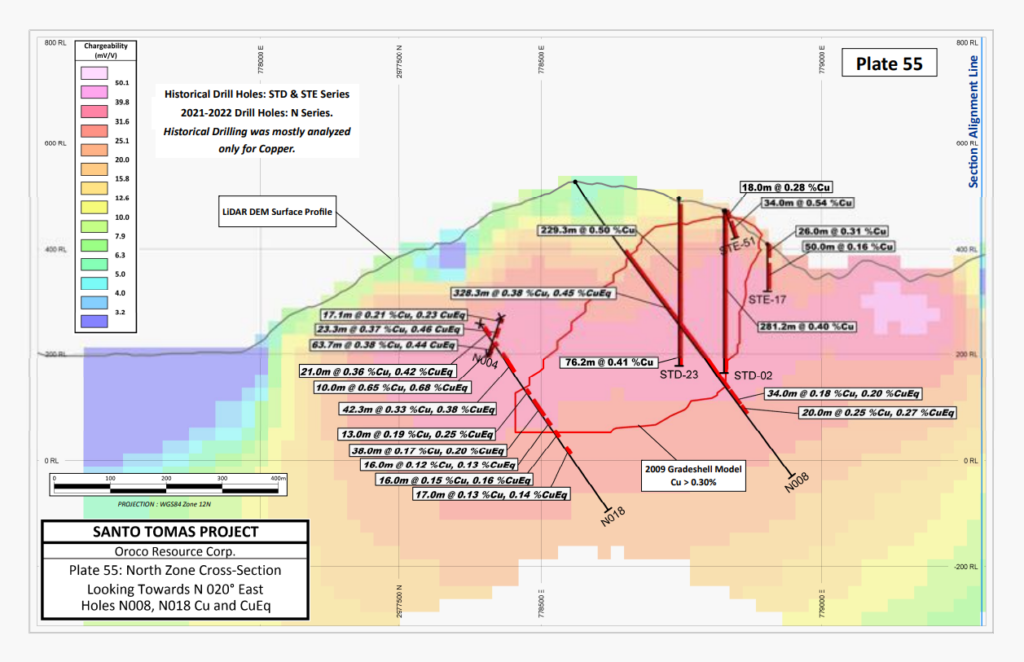
DRILL HOLE N018
Drill Hole N018 targeted the deposit at the western edge of the Gradeshell in the center of the strike length of the North Zone drill program. The hole returned several shorter intervals, including 21 m of 0.42% CuEq, 10 m of 0.68% CuEq and 42.3 m of 0.38% CuEq, over approximately 250 m, of which approximately 175 m was outside the Gradeshell (see Table 1 and Plate 55, attached, or at the Company’s website).
Table 1: Significant Assay Intervals in the Santo Tomas 2021-2022 Program, Holes N015 to N018:
| Drill Hole No. | Dip | From (m) | To (m) | Length (m) | Cu% | Mo (%) | Au g/t | Ag g/t | CuEq %* |
| N015 | -55 | 126.0 | 418.0 | 292.0 | 0.31 | 0.009 | 0.025 | 2.20 | 0.36 |
| N016 | -62 | 351.0 | 446.4 | 95.4 | 0.32 | 0.006 | 0.032 | 2.06 | 0.37 |
| “ | -62 | 464.0 | 508.6 | 44.7 | 0.39 | 0.016 | 0.022 | 3.68 | 0.46 |
| “ | -62 | 518.4 | 607.1 | 88.7 | 0.26 | 0.010 | 0.014 | 1.82 | 0.31 |
| N017 | -55 | 80.0 | 143.8 | 63.8 | 0.31 | 0.011 | 0.020 | 1.73 | 0.37 |
| “ | -55 | 153.8 | 313.0 | 159.2 | 0.22 | 0.010 | 0.020 | 1.38 | 0.28 |
| N018 | -55 | 203.0 | 224.0 | 21.0 | 0.36 | 0.011 | 0.017 | 2.54 | 0.42 |
| “ | -55 | 238.0 | 248.0 | 10.0 | 0.65 | 0.002 | 0.019 | 3.26 | 0.68 |
| “ | -55 | 263.8 | 306.1 | 42.3 | 0.33 | 0.012 | 0.017 | 1.96 | 0.38 |
Cu Equivalent (CuEq) % = Cu % + (Mo %*3.75) + (Au ppm*0.752). The commodity prices (3-year Average) used are in $US: Cu $3.20 /lb, Mo $12.00 /lb, and Au $1,650.00 /troy oz. * Ag values are not used in the CuEq calculations.
Drill Holes N015 to N018 test the North Zone deposit perpendicular to its structural attitude. Core intervals are within approximately 10% of true thickness. Assay results and cross-sections through the first eighteen North Zone drill holes (13,343 m of drilling) are available at the Company’s website.
In context, the results of N017 at the current southern extremity of the North Zone drill program, N018 at the center, and N016 at the northern end, demonstrate newly discovered shallow-seated mineralization located westward and in the hanging wall of the main North Zone deposit, indicating a broader North Zone deposit extending further westward and much closer to surface than previously modelled.
NORTH ZONE PROGRAM:
The North Zone drilling program is designed to confirm and expand the 2009 Gradeshell model, with the goal of delineating near-surface mineralization amenable to open-pit mining methods and the reduction of waste rock stripping ratios.
Drilling to date along 1,100 m of strike length (of which 1,000 m is along the historically indicated 1,600 m strike length of the North Zone deposit) has confirmed the NNE strike and moderately westerly dipping geometry of the deposit. Drill results confirm good grade mineralization contained in a gently north-plunging panel that is expressed at surface along the Santo Tomas ridge and extends consistently to about 400-500 m depth below the ridge, bottoming at approximately sea level.
Drilling in the North Zone to the end of 2022 will focus on supporting a mineral resource estimate by:
- Extending confirmation of North Zone mineralization southward along the remaining 600 m of historical strike length, with targets between the 100 m and 600 m elevation.
- Infill definition drilling.
- Definition drilling of newly discovered shallow-seated mineralization located westward and in the hanging wall of the main North Zone deposit.
Successful drilling of the new hanging wall zone will define mineralized tonnage between the Santo Tomas ridge and the Gradeshell, potentially significantly reducing the amount of waste rock stripping required to access North Zone mineralization.
SOUTH ZONE PROGRAM
Historical drilling, surface geological mapping and the Dias Geo 3D Induced Polarization survey have defined near-surface mineralization in the South Zone. Historical drilling documents good mineralization that is open to depth at 400 m below surface. The Company will commence a drill program targeted at testing the South Zone in 2022.
TECHNICAL INFORMATION AND QUALITY CONTROL / QUALITY ASSURANCE
The historical drilling data employed in this current exploration program was the subject of Data Verification procedures cited in the current Technical Report. Additional drill collar verifications were performed in the current program and collar locations fit closely to the 2021/2022 survey control. Appropriate QA/QC protocols governed geological logging, core sampling, sample preparation, analyses, and security during the current program, including quality controls with duplicates, standards, and blanks. Samples were submitted to the Mexican division of ALS Limited in Hermosillo, Mexico, for sample preparation to pulps. Sample pulps are then sent to ALS Canada Ltd. in Vancouver, Canada, for analysis. Total copper and molybdenum contents are determined by four-acid digestion with AAS finish. Gold was determined by fire assay of a 50-gram charge, or alternately, of a 30-gram charge (1 Assay ton).
QUALIFIED PERSON
Mr. Paul McGuigan, P. Geo., of Cambria Geosciences Inc., a “Qualified Person” (as defined in NI 43-101 –Standards for Disclosure for Mineral Projects) and a senior consulting geoscientist to the Company, has reviewed and approved the technical disclosures in this news release. The Company strictly adheres to CIM Best Practices Guidelines in conducting, documenting, and reporting the exploration activities on its projects.
ABOUT OROCO:
The Company holds a net 73.2% interest in the collective 1,172.9 ha Core Concessions of the Santo Tomas Project in NW Mexico and may increase that majority interest up to an 85.5% interest with a project investment of up to CAD$30 million. The Company also holds a 77.5% interest in 8,154.3 ha of mineral concessions surrounding and adjacent to the Core Concessions (for a total project area of 23,048 acres). The Project is situated within the Santo Tomas District, which extends from Santo Tomas up to the Jinchuan Group’s Bahuerachi project, approximately 14 km to the northeast. Santo Tomas hosts a significant copper porphyry deposit defined by prior exploration spanning the period from 1968 to 1994. During that time, the property was tested by over 100 diamond and reverse circulation drill holes, totalling approximately 30,000 meters. Based on data generated by these drill programs, a historical Prefeasibility Study was completed by Bateman Engineering Inc. in 1994.
The Santo Tomas Project is located within 160km of the Pacific deep-water port at Topolobampo and is serviced via highway and proximal rail (and parallel corridors of trunk grid power lines and natural gas) through the city of Los Mochis to the northern city of Choix. The property is reached by a 32 km access road originally built to service Goldcorp’s El Sauzal Mine in Chihuahua State.
For further information, please contact:
Richard Lock, CEO
Oroco Resource Corp.
Tel: 604-688-6200
Email: [email protected]
www.orocoresourcecorp.com
Neither TSX Venture Exchange nor its Regulation Services Provider (as that term is defined in the policies of the TSX Venture Exchange) accepts responsibility for the adequacy or accuracy of this release.
Cautionary Note Regarding Forward Looking Information
This news release includes certain “forward-looking information” and “forward-looking statements” (collectively “forward-looking statements”) within the meaning of applicable Canadian securities legislation. All statements, other than statements of historical fact included herein, including without limitation, statements relating to future events or achievements of the Company, are forward-looking statements. There can be no assurance that such forward-looking statements will prove to be accurate, and actual results and future events could differ materially from those anticipated or implied in such statements. Many factors, both known and unknown, could cause actual results, performance or achievements to be materially different from the results, performance or achievements that are or may be expressed or implied by such forward-looking statements. Readers should not place undue reliance on the forward-looking statements and information contained in this news release concerning these matters. Oroco does not assume any obligation to update the forward-looking statements should they change, except as required by law.
Contact Data
Richard Lock, CEO
Oroco Resource Corp.
(604) 688-6200
[email protected]

Original Article: https://www.globenewswire.com/news-release/2022/08/24/2503881/0/en/OROCO-SUCCESSFULLY-TESTS-WESTERN-SIDE-OF-NORTH-ZONE.html


