Melbourne, Australia and Vancouver, Canada – February 25, 2026 – TheNewswire – Mithril Silver and Gold Limited (“Mithril” or the “Company”) (TSXV: MSG) (ASX: MTH) (OTCQB: MTIRF) is pleased to provide details of continued exploration progress at Mithril’s Copalquin and La Dura properties, Durango State, Mexico.
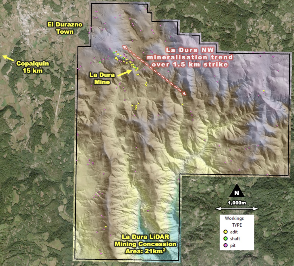
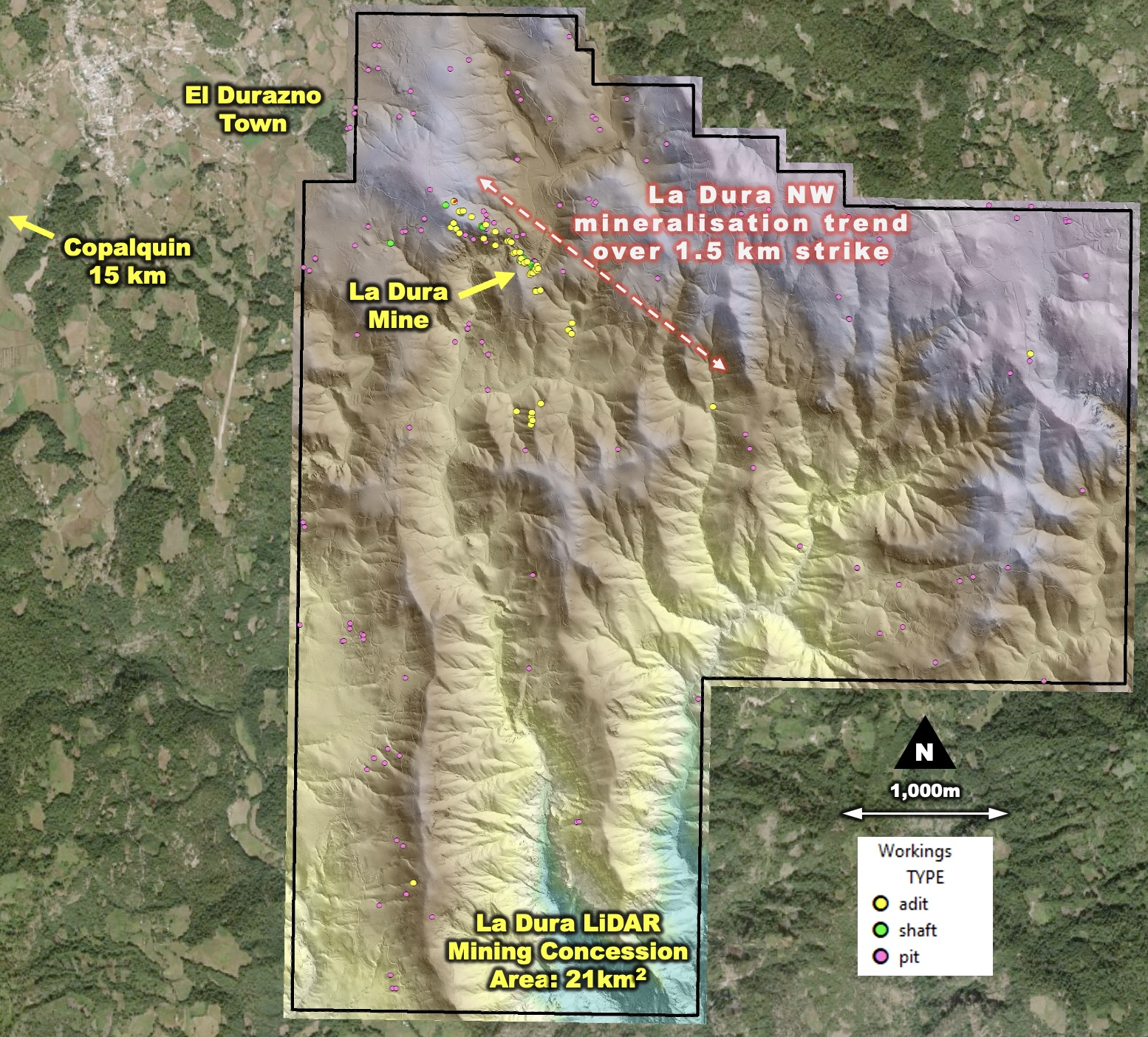
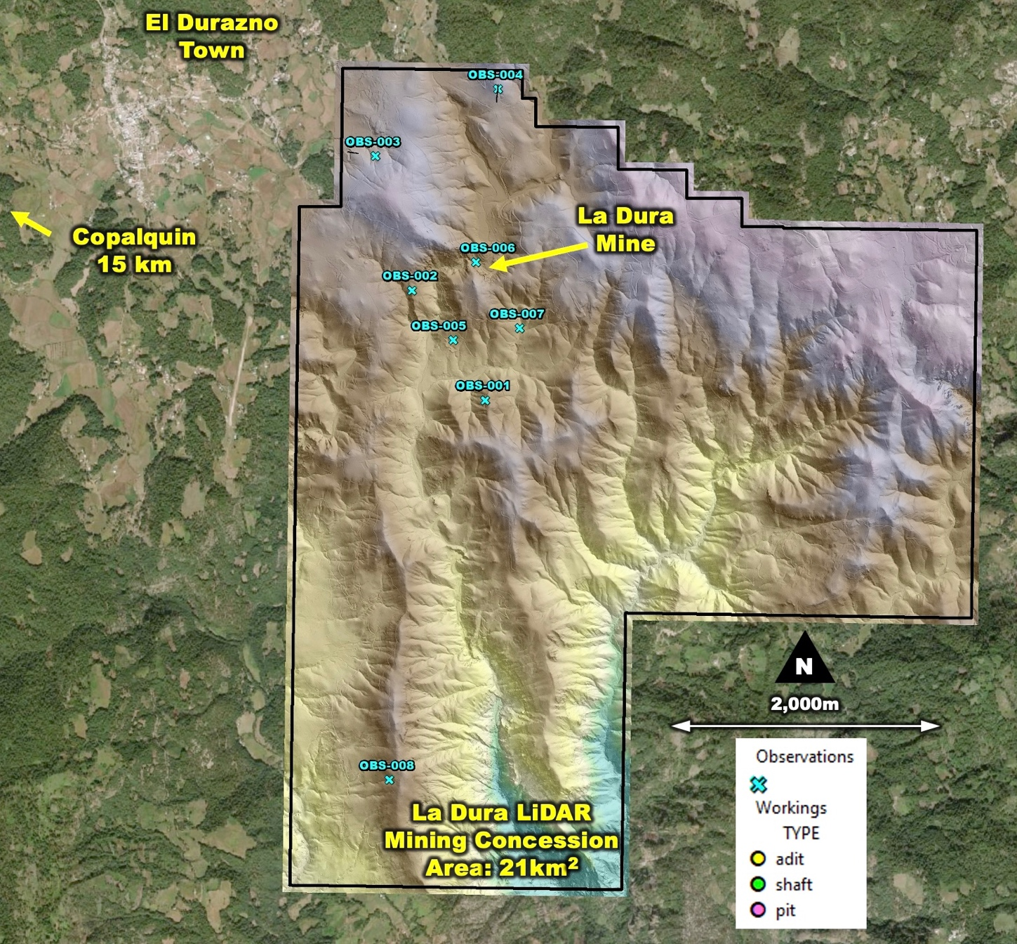
A LiDAR survey has been completed over the Company’s full 21km2 of mining concessions that cover the La Dura gold-silver district in Durango State, Mexico.
The LiDAR survey has provided high-resolution aerial photography and bare-earth digital terrain model (DTM) that virtually ‘strips away’ the vegetation, revealing amazing geology and structural detail beneath. Highlights include:
- Historic mine shafts – 18
- Historic adits (mine tunnels) – 44
- Historic mine and prospecting pits – 134
- A second cluster of adits and workings located 1 km south in the concession area
Conclusions from our external consultant GeoCloud Analytics reveals a strong trend up to 1.5 km long and 300 m wide with workings (including the 4 level La Dura mine) along 5 repeated structures. This is an obvious and high-priority drill target. Details and figures from the LiDAR study follow below.
- The aerial magnetic surveys have been completed over the Copalquin District the La Dura property mining concession areas with final reporting anticipated shortly. Along with detailed mapping, sampling, spectral surveys and petrography work, the survey output will provide the data to finalise the drill plan targeting key structural ‘feeder’ targets and progress the District-wide exploration.
- Phase IV Drilling at Target 1 to complete the resource update is progressing and anticipated to be completed over the next two months with reporting to follow. Considerable work has been completed to build and robust geologic model for the updated resource estimation. The resource for Target 1 is expected to provide a strong basis for the future development of the Copalquin District plus considerable exploration upside across the multiple target areas.
- The maiden drill programme at Target 3 is progressing. Early signs are highly encouraging, with mineralised quartz vein structures intercepted at predicted depths (assays pending). Maiden drilling is testing several locations with within the target area. The aerial magnetic survey and drill results will provide data to expand the programme at Target 3 and adjacent areas.
“The completion of the LiDAR survey over La Dura has significantly enhanced our understanding of the structural features and historic workings across the 21km² mining concession area,” said John Skeet, Managing Director and CEO. “The identification of a 1.5 kilometre long structural corridor hosting multiple historic shafts and adits, including the four-level La Dura mine, defines an obvious high-priority drill target. At our flagship Copalquin District, Phase IV drilling at Target 1 is advancing well towards the updated resource, while maiden drilling at Target 3 has intersected mineralised quartz veins at predicted depths (assays pending). Together with the recently completed aerial magnetic surveys, we are rapidly refining and prioritising district-scale feeder targets at both properties.”
Copalquin District Area – 2026
Mithril is undertaking an aggressive exploration program in 2026, with up to 25,000 metres of drilling planned during the first 8 months of the year across the Copalquin District. Work is focus on expanding known mineralized zones, testing new high-priority targets, integrating district-wide geophysical data, and continuing to advance the Company’s district-scale exploration thesis. The district features over 100 historic underground workings (c.1850 – 1910) including several multi-level mines and 200 small surface workings. Mapping and sampling across the lower half of the 70 km2 mining concession area demonstrates and a large epithermal silver-gold system with multiple target areas for potential resource growth plus the conduit system responsible for the widespread silver and gold mineralisation.
The northern half of the Copalquin concession area features large areas of alteration. The LiDAR image shows evidence of historic mining activity and indicates some key structures. Along with historic sampling data, the northern section of the property presents as a potentially significant large exploration area within Mithril’s Copalquin mining concessions.
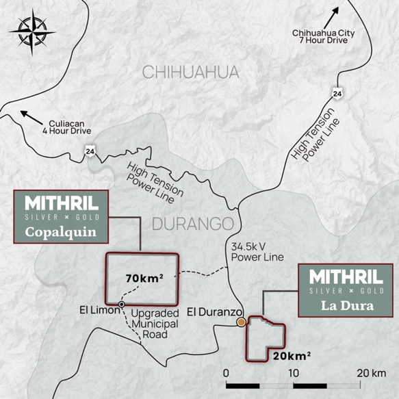
The nearby 21 km2 La Dura property has recently been added to the portfolio providing a brown field property with a database of mapping, sampling and drilling. There is evidence of significant historic mining activity within the concession area, including the 4-level high-grade La Dura mine. An aerial magnetic survey has been flown (interpretation pending).
Details of La Dura LiDAR Survey
The LiDAR survey over the La Dura mining concession area has provided high-resolution aerial photography and bare-earth digital terrain model (DTM). This virtually ‘strips away’ the vegetation, revealing amazing geology and structural detail beneath LiDAR uses laser beams shot from an aircraft (more than 1 million per second) to measure their reflectance and distance to build a survey accurate 3D model of the ground beneath. Below are figures from the LiDAR consultant’s interpretations of the LiDAR images, observations and recommendations.
Recommendations Based in LiDAR Observations
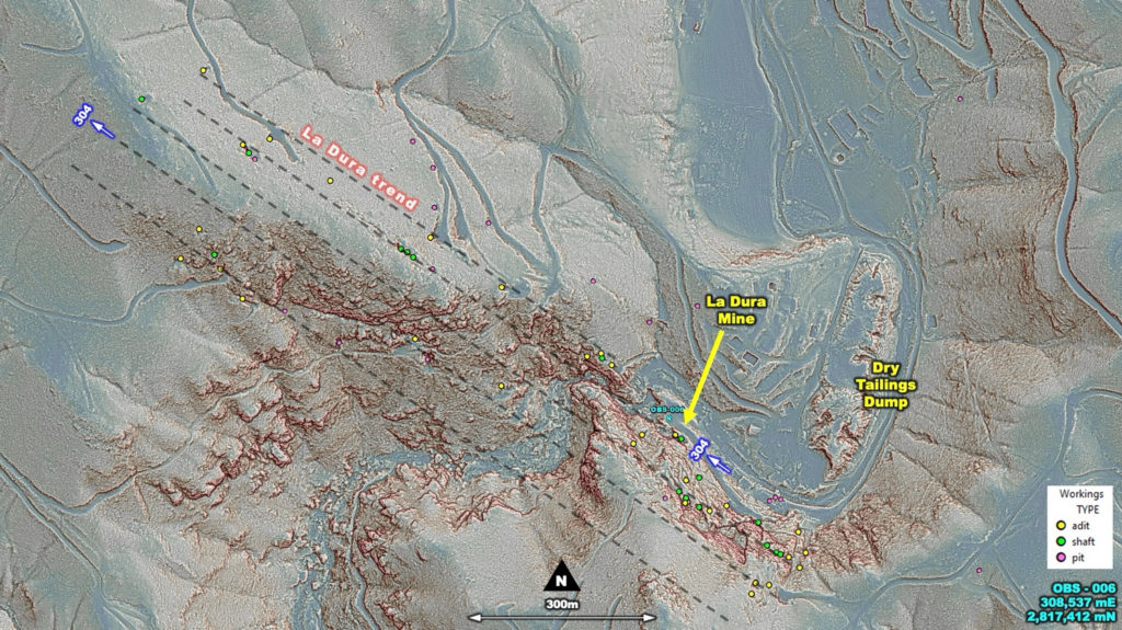
Repetition of the La Dura Mine Trend
Workings identified around the La Dura Mine appear to align on a 304 azimuth trend. Projecting this trend to the South-West sees other pit-chains of workings also align suggesting a stacked vein system. While the La Dura trend appears continually mineralized along strike, the S-W projects are not as continuous. From locations of these workings, prospecting extending from and along the trend should be undertaken to in-fill. The canyon immediately South of La Dura offers excellent bedrock exposure for potential vein and structure review at depth, being over 130 m deep from the peak.
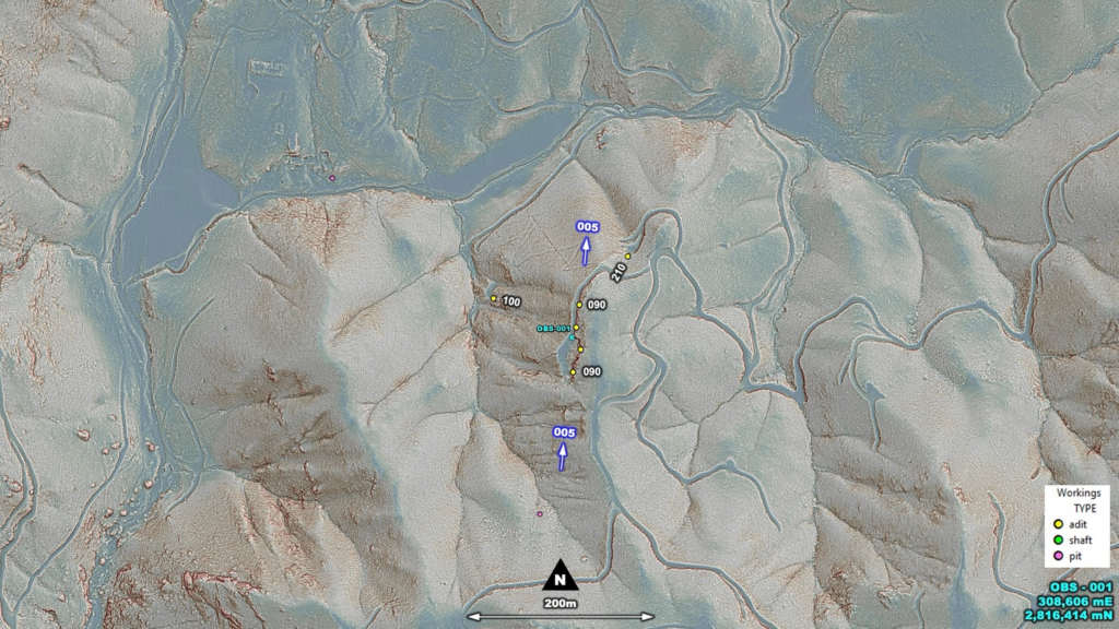
Adits described in OBS-001 trending North
The Northerly trending adits (005 azimuth) driven into the ridgeline at this location based on orientation appear to be a different system to that of La Dura trending 304 azimuth. If continuous, OBS-001 projected North to the intersection of La Dura would make an interesting target. The adit cluster noted in OBS-007 may be an example of this structural intersection.
Grab sampling of the adits and shafts identified
The adits and shafts mapped from LiDAR offer good opportunities for grab sampling, especially away from the known mine locations being artisanal in nature. There already exists a database of sampling within the mining concession area.
ABOUT THE COPALQUIN AND LA DURA GOLD SILVER PROJECTS
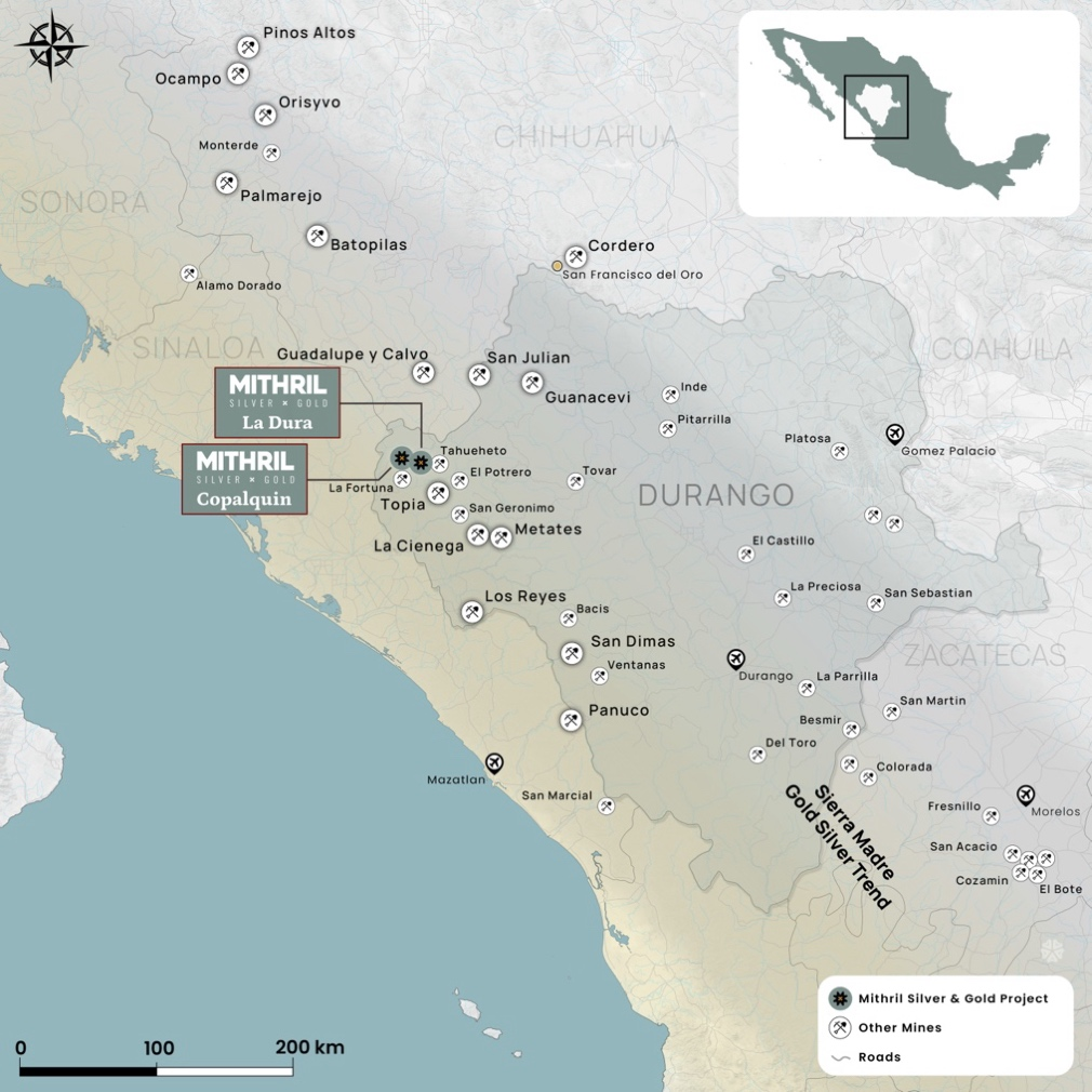
The Copalquin mining district is located in Durango State, Mexico and covers an entire mining district of 70km2 containing several dozen historic gold and silver mines and workings, ten of which had notable production. The district is within the Sierra Madre Gold Silver Trend which extends north-south along the western side of Mexico and hosts many gold and silver districts.
Multiple mineralisation events, young intrusives thought to be system-driving heat sources, widespread alteration together with extensive surface vein exposures and dozens of historic mine workings, identify the Copalquin mining district as a major epithermal centre for Gold and Silver.
Within 15 months of drilling in the Copalquin District, Mithril delivered a maiden JORC mineral resource estimate at the first of several target areas (Target 1), demonstrating the high-grade gold and silver resource potential for the district. This maiden resource is detailed below (see ASX release 17 November 2021)^ and a NI 43-101 Technical Report filed on SEDAR+
Target 1 Maiden Resource:
- Indicated 691 kt @5.43 g/t gold, 114 g/t silver for 121,000 oz gold plus 2,538,000 oz silver
- Inferred 1,725 kt @4.55 g/t gold, 152 g/t silver for 252,000 oz gold plus 8,414,000 oz silver
(using a cut-off grade of 2.0 g/t AuEq*)
- 28.6% of the resource tonnage is classified as indicated
Table 1 Mineral resource estimate at Target 1 El Refugio – La Soledad using a cut-off grade of 2.0 g/t AuEq*
| Tonnes(kt) | Tonnes(kt) | Gold(g/t) | Silver(g/t) | Gold Eq.* (g/t) | Gold(koz) | Silver(koz) | Gold Eq.* (koz) | |
| El Refugio | Indicated | 691 | 5.43 | 114.2 | 7.06 | 121 | 2,538 | 157 |
| Inferred | 1,447 | 4.63 | 137.1 | 6.59 | 215 | 6,377 | 307 | |
| La Soledad | Indicated | – | – | – | – | – | – | – |
| Inferred | 278 | 4.12 | 228.2 | 7.38 | 37 | 2,037 | 66 | |
| Total | Indicated | 691 | 5.43 | 114.2 | 7.06 | 121 | 2,538 | 157 |
| Inferred | 1,725 | 4.55 | 151.7 | 6.72 | 252 | 8,414 | 372 |
* In determining the gold equivalent (AuEq.) grade for reporting, a gold:silver price ratio of 70:1 was determined, using the formula: AuEq grade = Au grade + ((Ag grade/70) x (Ag recovery/Au recovery)). The metal prices used to determine the 70:1 ratio are the cumulative average prices for 2021: gold USD1,798.34 and silver: USD25.32 (actual is 71:1) from kitco.com.
For silver equivalent (AgEq.) grade reporting, the same factors as above are used with the formula AgEq grade = Ag grade + ((Au grade x 70) x (Au recovery/Ag recovery))
At this early stage, the metallurgical recoveries were assumed to be equal (93%). Subsequent preliminary metallurgical test work produced recoveries of 91% for silver and 96% for gold (ASX Announcement 25 February 2022) and these will be used when the resource is updated in the future. In the Company’s opinion there is reasonable potential for both gold and silver to be extracted and sold.
^ The information in this report that relates to Mineral Resources or Ore Reserves is based on information provided in the following ASX announcement: 17 Nov 2021 – MAIDEN JORC RESOURCE 529,000 OUNCES @ 6.81G/T (AuEq*), which includes the full JORC MRE report, also available on the Mithril Resources Limited Website.
The Company confirms that it is not aware of any new information or data that materially affects the information included in the original market announcement and that all material assumptions and technical parameters underpinning the estimates in the relevant market announcement continue to apply and have not materially changed. The company confirms that the form and context in which the Competent Person’s findings are presented have not been materially modified from the original market announcement.
Mining study (conceptual) and metallurgical test work supports the development of the El Refugio-La Soledad resource with conventional underground mining methods indicated as being appropriate and with high gold-silver recovery to produce metal on-site with conventional processing. The average vein width is approximately 4.5 metres.
Mithril is currently exploring in the Copalquin District to expand the resource footprint, demonstrating its multi-million-ounce gold and silver potential. Mithril has an exclusive option to purchase 100% interest in the Copalquin mining concessions by paying US$10M on or any time before 7 August 2028.
The La Dura Property consists of 5 contiguous mining concessions with a total area of 2,052 hectares and located in Durango State, Mexico, 5 km from the town of El Durazno and 15 km from Mithril’s flagship Copalquin property.
The property hosts a significant Au‐Ag sheeted to stockwork vein system associated with NW striking faults in Tertiary rhyolite. Mineralization occurs on surface along 650 metres of strike and has been mined in the San Manuel shoot at the La Dura historic mine, to about 140 metres depth. Veins consist of low sulphide veins with little to no alteration of the host rhyolite tuff. Historically, the veins have been exploited and explored solely on the basis of the underground working and assays. The project warrants property scale mapping, wide spaced soil sampling and channel sampling to develop targets for drill testing. LiDAR and aerial magnetic surveys (report pending) have been completed.
The veins at the various workings appear to be hosted by Upper Series volcanic rocks and may have significant depth potential should they extend into the lower series andesitic rocks at some greater depth.
-ENDS-
Released with the authority of the Board.
For further information contact:
John Skeet
Managing Director and CEO
[email protected]
+61 435 766 809
NIKLI COMMUNICATIONS
Corporate Communications
[email protected]
[email protected]
The Australian Securities Exchange has not reviewed and does not accept responsibility for the accuracy or adequacy of this release.
Neither TSX Venture Exchange nor its Regulation Services Provider (as that term is defined in policies of the TSX Venture Exchange) accepts responsibility for the adequacy or accuracy of this release.
Competent Persons Statement – JORC
The information in this announcement that relates to the LiDAR survey results, sampling techniques and data, metallurgical test results, mineral processing and project development and study work has been compiled by Mr John Skeet who is Mithril’s CEO and Managing Director. Mr Skeet is a Fellow of the Australasian Institute of Mining and Metallurgy. This is a Recognised Professional Organisation (RPO) under the Joint Ore Reserves Committee (JORC) Code.
Mr Skeet has sufficient experience of relevance to the styles of mineralisation and the types of deposits under consideration, and to the activities undertaken, to qualify as a Competent Person as defined in the 2012 Edition of the Joint Ore Reserves Committee (JORC) Australasian Code for Reporting of Exploration Results, Mineral Resources and Ore Reserves. Mr Skeet consents to the inclusion in this report of the matters based on information in the form and context in which it appears. The Australian Securities Exchange has not reviewed and does not accept responsibility for the accuracy or adequacy of this release.
The information in this announcement that relates to Mineral Resources is reported by Mr Rodney Webster, former Principal Geologist at AMC Consultants Pty Ltd (AMC), who is a Member of the Australian Institute of Geoscientists. The report was peer reviewed by Andrew Proudman, Principal Consultant at AMC. Mr Webster is acting as the Competent Person, as defined in the 2012 Edition of the Joint Ore Reserves Committee (JORC) Australasian Code for Reporting of Exploration Results, Mineral Resources and Ore Reserves, for the reporting of the Mineral Resource estimate. A site visit was carried out by Jose Olmedo a geological consultant with AMC, in September 2021 to observe the drilling, logging, sampling and assay database. Mr Webster consents to the inclusion in this report of the matters based on information in the form and context in which it appears
Qualified Persons – NI 43-101
Scientific and technical information in this Report has been reviewed and approved by Mr John Skeet (FAUSIMM, CP) Mithril’s Managing Director and Chief Executive Officer. Mr John Skeet is a qualified person within the meaning of NI 43-101.
Samples are sent to ALS Global with sample preparation performed in Chihuahua City, Mexico and assaying of sample pulps performed in North Vancouver, BC, Canada.