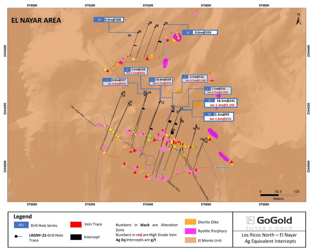
2,192 g/t AgEq over 1.3m within 18.2m of 241 g/t AgEq at El Nayar
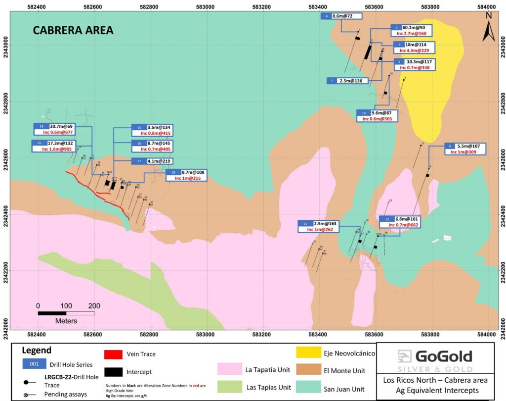
905 g/t AgEq over 1.6m within 17.3m of 132 g/t AgEq at Gran Cabrera
HALIFAX, NS, Sept. 14, 2022 /CNW/ – GoGold Resources Inc. (TSX: GGD) (OTCQX: GLGDF) (“GoGold”, “the Company”) is pleased to release the results of 6 drill holes from the El Nayar area and 15 drill holes from the Gran Cabrera area within Los Ricos North property. The El Nayar and Gran Cabrera areas are targets of the Los Ricos North regional exploration drilling program. Hole LRGNY-21-027 at El Nayar intersected 2,192 g/t silver equivalent (“AgEq”) over 1.3m, contained within 18.2m of 241 g/t AgEq. At Gran Cabrera, hole LRGCB-22-020 intersected 905 g/t AgEq over 1.6m, contained within 17.3m of 132 g/t AgEq. See Table 1 for a breakdown of gold and silver values at El Nayar and Table 2 for Gran Cabrera.
“This drilling represents results from exploration from outside of our resource areas and are some of the first results from these new targets. These targets will require future drilling which will be aimed at developing future resources. At Gran Cabrera, we encountered voids in our drilling due to historical underground mining on half of the holes which we drilled, with the voids averaging about 4 metres. As we continue exploring this area, our focus is locating areas where the high grade portion of the veins has not been mined out,” said Brad Langille, President and CEO. “We’ve shifted some of our drilling rigs to Los Ricos South as a re-evaluation of our data has opened up additional areas for potential growth of the mineral resource. In addition to our drilling, we continue to work on consolidation of additional ground in Los Ricos South and expect an update on that in the near future.”
| Hole ID | Area / Vein | From | To | Length1 | Au | Ag | AuEq2 | AgEq2 |
| (m) | (m) | (m) | (g/t) | (g/t) | (g/t) | (g/t) | ||
| LRGNY-21-022 | El Nayar | 261.7 | 262.9 | 1.2 | 0.45 | 45.0 | 1.05 | 79.0 |
| and | 283.9 | 285.1 | 1.2 | 0.26 | 126.0 | 1.94 | 145.5 | |
| LRGNY-21-024 | El Nayar | 0.0 | 10.5 | 10.5 | 0.18 | 60.8 | 0.99 | 74.0 |
| including | 8.5 | 9.5 | 1.0 | 0.83 | 275.0 | 4.50 | 337.3 | |
| LRGNY-21-025 | El Nayar | 65.7 | 71.0 | 5.3 | 0.38 | 66.5 | 1.27 | 95.1 |
| including | 68.7 | 69.7 | 1.0 | 1.42 | 124.0 | 3.07 | 230.5 | |
| and | 170.0 | 171.8 | 1.8 | 0.15 | 116.3 | 1.70 | 127.8 | |
| LRGNY-21-026 | El Nayar | 105.9 | 106.8 | 0.9 | 6.66 | 0.2 | 6.66 | 499.7 |
| LRGNY-21-027 | El Nayar | 47.1 | 49.2 | 2.1 | 1.27 | 137.2 | 3.09 | 232.1 |
| and | 57.5 | 58.5 | 1.0 | 0.77 | 152.0 | 2.80 | 209.8 | |
| and | 185.9 | 195.2 | 9.3 | 0.15 | 89.0 | 1.33 | 100.1 | |
| including | 190.1 | 191.7 | 1.6 | 0.77 | 454.7 | 6.83 | 512.2 | |
| and | 207.6 | 225.7 | 18.2 | 1.54 | 125.4 | 3.21 | 241.0 | |
| including | 212.8 | 217.3 | 4.6 | 6.02 | 440.5 | 11.90 | 892.1 | |
| including | 213.5 | 214.8 | 1.3 | 20.40 | 662.0 | 29.23 | 2,192.0 | |
| LRGNY-21-030 | El Nayar | 82.0 | 86.4 | 4.5 | 0.18 | 53.3 | 0.89 | 66.6 |
| including | 84.9 | 85.4 | 0.6 | 0.93 | 254.0 | 4.32 | 323.7 |
- Not true width
- AqEq converted using a silver to gold ratio of 75:1 at recoveries of 100%
- Holes LRGNY-21-028 and LRGNY-21-029 did not intersect significant mineralization.
El Nayar is located approximately 6 kilometres north-west of the La Trini deposit within Los Ricos North (see Figure 3). It consists of multiple subvertical veins and stockwork mineralization, and limited historical underground mining. La Castellana vein is an epithermal argentiferous quartz vein ranging from 1m to 2m in width and averaging about 1.20 m. The vein contains minor credits in gold, zinc, lead and copper in addition to the silver. The mineralization is a mixture of sulphide and oxide species; galena, sphalerite, pyrite, unidentified argentiferous minerals (mostly black), copper carbonates and some manganese minerals were observed underground.
Gran Cabrera is located approximately 2 kilometres northwest of La Trini (see Figure 3). The Gran Cabrera mega-system contains stockworks, breccia hosted ore bodies, and large vein feeder sub-systems at the intersection of the Sierra Madre and the Trans Mexican Volcanic Arc. Within the property there are more than fifteen significant old precious metals mines that historically produced high grade silver-gold ore periodically over a period of more than 350 years beginning with their discovery by early Spanish Conquistadors. The Company’s exploration team has conducted a detailed sampling and mapping program within the last year and has identified dozens of historical underground workings along an E-W trending structure over a distance of 1,700 metres along strike and widths extending more than 20 metres.
| Hole ID | Area / Vein | From | To | Length1 | Au | Ag | AuEq2 | AgEq2 |
| (m) | (m) | (m) | (g/t) | (g/t) | (g/t) | (g/t) | ||
| LRGCB-22-001 | Gran Cabrera | 50.0 | 60.3 | 10.3 | 0.07 | 111.5 | 1.56 | 116.7 |
| including | 50.0 | 50.7 | 0.7 | 0.17 | 335.2 | 4.64 | 347.7 | |
| and | 115.7 | 118.8 | 3.1 | 0.13 | 116.4 | 1.68 | 126.0 | |
| LRGCB-22-002 | Gran Cabrera | 18.2 | 78.2 | 60.1 | 0.06 | 45.4 | 0.67 | 50.1 |
| including | 63.0 | 65.7 | 2.7 | 0.10 | 152.3 | 2.13 | 159.7 | |
| and | 84.0 | 102.0 | 18.0 | 0.21 | 61.7 | 1.04 | 77.7 | |
| including | 84.0 | 86.3 | 2.3 | 0.02 | 153.8 | 2.07 | 155.5 | |
| LRGCB-22-003 | Gran Cabrera | 23.5 | 41.4 | 18.0 | 0.13 | 105.0 | 1.53 | 114.4 |
| including | 35.7 | 40.0 | 4.3 | 0.39 | 199.4 | 3.05 | 228.7 | |
| including | 36.6 | 38.6 | 2.0 | 0.34 | 252.7 | 3.71 | 278.5 | |
| and | 68.0 | 69.0 | 1.0 | 2.81 | 25.3 | 3.15 | 236.3 | |
| LRGCB-22-004 | Gran Cabrera | 24.1 | 24.7 | 0.6 | 0.07 | 66.3 | 0.95 | 71.5 |
| LRGCB-22-007 | Gran Cabrera | 52.5 | 55.0 | 2.5 | 0.06 | 130.9 | 1.81 | 135.6 |
| LRGCB-22-009 | Gran Cabrera | 26.0 | 31.5 | 5.5 | 0.09 | 100.4 | 1.43 | 107.4 |
| including | 29.5 | 30.5 | 1.0 | 0.23 | 291.3 | 4.12 | 308.7 | |
| and | 138.6 | 139.5 | 0.9 | 1.82 | 115.1 | 3.35 | 251.5 | |
| LRGCB-22-010 | Gran Cabrera | 88.6 | 98.2 | 9.6 | 0.17 | 73.7 | 1.15 | 86.6 |
| including | 91.9 | 92.4 | 0.6 | 1.83 | 368.3 | 6.74 | 505.2 | |
| LRGCB-22-012 | Gran Cabrera | 20.2 | 22.6 | 2.5 | 0.20 | 147.9 | 2.17 | 162.7 |
| including | 21.7 | 22.6 | 1.0 | 0.22 | 244.7 | 3.49 | 261.5 | |
| LRGCB-22-013 | Gran Cabrera | 49.5 | 56.3 | 6.8 | 0.31 | 77.7 | 1.35 | 101.1 |
| including | 55.6 | 56.3 | 0.7 | 1.60 | 541.8 | 8.82 | 661.5 | |
| LRGCB-22-015 | Gran Cabrera | 4.8 | 5.7 | 1.0 | 1.11 | 7.6 | 1.21 | 90.9 |
| and | 35.3 | 38.8 | 3.5 | 0.35 | 107.9 | 1.79 | 134.0 | |
| including | 36.2 | 37.0 | 0.8 | 1.17 | 326.8 | 5.53 | 414.5 | |
| and | 55.5 | 57.0 | 1.5 | 0.78 | 180.7 | 3.18 | 238.9 | |
| LRGCB-22-016 | Gran Cabrera | 47.6 | 56.3 | 8.7 | 0.23 | 128.3 | 1.94 | 145.4 |
| including | 52.6 | 53.3 | 0.7 | 0.64 | 356.9 | 5.40 | 404.7 | |
| LRGCB-22-017 | Gran Cabrera | 69.5 | 74.9 | 4.1 | 0.26 | 199.6 | 2.92 | 218.8 |
| including | 69.5 | 70.2 | 0.7 | 0.47 | 313.4 | 4.65 | 348.5 | |
| LRGCB-22-018 | Gran Cabrera | 1.5 | 2.2 | 0.7 | 0.11 | 100.0 | 1.44 | 107.9 |
| including | 25.2 | 26.1 | 1.0 | 0.28 | 193.8 | 2.87 | 215.1 | |
| LRGCB-22-019 | Gran Cabrera | 38.1 | 70.9 | 30.7 | 0.06 | 64.4 | 0.92 | 68.9 |
| including | 53.9 | 59.7 | 3.8 | 0.31 | 354.6 | 5.03 | 377.6 | |
| including | 56.5 | 57.2 | 0.6 | 0.37 | 648.5 | 9.02 | 676.5 | |
| LRGCB-22-020 | Gran Cabrera | 76.0 | 93.3 | 17.3 | 0.19 | 118.1 | 1.76 | 132.1 |
| including | 82.4 | 83.9 | 1.6 | 1.28 | 808.9 | 12.06 | 904.6 |
- Not true width
- AqEq converted using a silver to gold ratio of 75:1 at recoveries of 100%
- Holes LRGCB-22-005,006,008,011,014 did not intercept significant mineralization
| Hole ID | Easting | Northing | Elevation | Azimuth | Dip | Length |
| LRGNY-21-022 | 578393 | 2344249 | 765 | 319 | 200 | -70 |
| LRGNY-21-024 | 578477 | 2344118 | 726 | 235 | 200 | -45 |
| LRGNY-21-025 | 578505 | 2344191 | 741 | 322 | 200 | -45 |
| LRGNY-21-026 | 578361 | 2344458 | 705 | 195 | 200 | -65 |
| LRGNY-21-027 | 578506 | 2344191 | 741 | 235 | 200 | -57 |
| LRGNY-21-030 | 578452 | 2344488 | 651 | 143 | 200 | -45 |
| LRGCB-22-001 | 583580 | 2343010 | 712 | 152 | 200 | -45 |
| LRGCB-22-002 | 583581 | 2343011 | 712 | 113 | 200 | -55 |
| LRGCB-22-003 | 583581 | 2343011 | 712 | 288 | 0 | -90 |
| LRGCB-22-004 | 583537 | 2343048 | 684 | 213 | 200 | -45 |
| LRGCB-22-007 | 583622 | 2342978 | 725 | 125 | 200 | -65 |
| LRGCB-22-009 | 583788 | 2342562 | 783 | 249 | 200 | -45 |
| LRGCB-22-010 | 583647 | 2342892 | 748 | 138 | 200 | -50 |
| LRGCB-22-012 | 583544 | 2342325 | 815 | 141 | 200 | -45 |
| LRGCB-22-013 | 583607 | 2342323 | 832 | 116 | 200 | -45 |
| LRGCB-22-015 | 582666 | 2342521 | 930 | 62 | 200 | -45 |
| LRGCB-22-016 | 582666 | 2342521 | 930 | 113 | 200 | -70 |
| LRGCB-22-017 | 582667 | 2342521 | 930 | 116 | 0 | -90 |
| LRGCB-22-018 | 582698 | 2342513 | 942 | 110 | 200 | -55 |
| LRGCB-22-019 | 582649 | 2342542 | 917 | 91 | 200 | -55 |
| LRGCB-22-020 | 582649 | 2342542 | 917 | 105 | 0 | -90 |
VRIFY Slide Deck and 3D Presentation
VRIFY is a platform being used by companies to communicate with investors using 360° virtual tours of remote mining assets, 3D models and interactive presentations. VRIFY can be accessed by website and with the VRIFY iOS and Android apps.
The VRIFY Slide Deck and 3D Presentation for GoGold can be viewed at: https://vrify.com/decks/10437 and on the Company’s website at: www.gogoldresources.com.
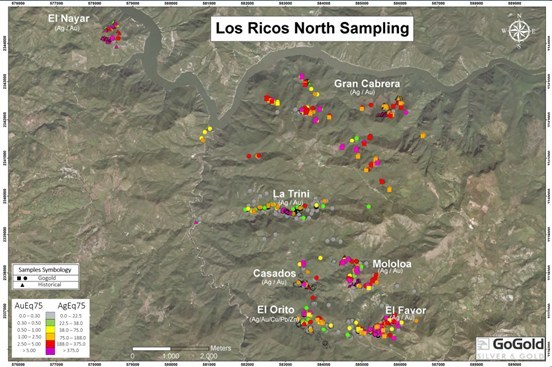
Los Ricos District Exploration Projects
The Company’s two exploration projects at its Los Ricos Property are in Jalisco state, Mexico. The Los Ricos South Project began in March 2019 and an initial Mineral Resource was announced on July 29, 2020 which disclosed a Measured & Indicated Mineral Resource of 63.7 million ounces AgEq grading 199 g/t AgEq contained in 10.0 million tonnes, and an Inferred Mineral Resource of 19.9 million ounces AgEq grading 190 g/t AgEq contained in 3.3 million tonnes. An initial PEA on the project was announced on January 20, 2021 indicating an NPV5% of US$295M.
The Los Ricos North Project was launched in March 2020 and an initial Mineral Resource was announced on December 7, 2021, which disclosed an Indicated Mineral Resource of 87.8 million ounces AgEq grading 122 g/t AgEq contained in 22.3 million tonnes, and an Inferred Mineral Resource of 73.2 million ounces AgEq grading 111 g/t AgEq contained in 20.5 million tonnes. The Company has a drill program for an additional 100,000 metres of drilling for 2022 in place.
Procedure, Quality Assurance / Quality Control and Data Verification
The diamond drill core (HQ size) is geologically logged, photographed and marked for sampling. When the sample lengths are determined, the full core is sawn with a diamond blade core saw with one half of the core being bagged and tagged for assay. The remaining half portion is returned to the core trays for storage and/or for metallurgical test work.
The sealed and tagged sample bags are transported to the ActLabs facility in Zacatecas, Mexico. ActLabs crushes the samples and prepares 200-300 gram pulp samples with ninety percent passing Tyler 150 mesh (106μm). The pulps are assayed for gold using a 50-gram charge by fire assay (Code 1A2-50) and over limits greater than 10 grams per tonne are re-assayed using a gravimetric finish (Code 1A3-50). Silver and multi-element analysis is completed using total digestion (Code 1F2 Total Digestion ICP). Over limits greater than 100 grams per tonne silver are re-assayed using a gravimetric finish (Code 8-Ag FA-GRAV Ag).
Quality assurance and quality control (“QA/QC”) procedures monitor the chain-of-custody of the samples and includes the systematic insertion and monitoring of appropriate reference materials (certified standards, blanks and duplicates) into the sample strings. The results of the assaying of the QA/QC material included in each batch are tracked to ensure the integrity of the assay data. All results stated in this announcement have passed GoGold’s QA/QC protocols.
Mr. David Duncan, P. Geo. is the qualified person as defined by National Instrument 43-101 and is responsible for the technical information of this release.
About GoGold Resources
GoGold Resources (TSX: GGD) is a Canadian-based silver and gold producer focused on operating, developing, exploring and acquiring high quality projects in Mexico. The Company operates the Parral Tailings mine in the state of Chihuahua and has the Los Ricos South and Los Ricos North exploration projects in the state of Jalisco. Headquartered in Halifax, NS, GoGold is building a portfolio of low cost, high margin projects. For more information visit gogoldresources.com.
For further information: Please contact:
Steve Low
Corporate Development
GoGold Resources
T: 416 855 0435
E: [email protected]
CAUTIONARY STATEMENT:
The securities described herein have not been, and will not be, registered under the United States Securities Act of 1933, as amended (the “U.S. Securities Act”), or any state securities laws, and may not be offered or sold within the United States or to, or for the benefit of, U.S. persons (as defined in Regulation S under the U.S. Securities Act) except in compliance with the registration requirements of the U.S. Securities Act and applicable state securities laws or pursuant to exemptions therefrom. This release does not constitute an offer to sell or a solicitation of an offer to buy of any of GoGold’s securities in the United States.
This news release may contain “forward-looking information” as defined in applicable Canadian securities legislation. All statements other than statements of historical fact, included in this release, including, without limitation, statements regarding the Los Ricos South and North projects, and future plans and objectives of GoGold, including the intention to undertake further exploration at Los Ricos North, and the prospect of further discoveries there, constitute forward looking information that involve various risks and uncertainties. Forward-looking information is based on a number of factors and assumptions which have been used to develop such information but which may prove to be incorrect, including, but not limited to, assumptions in connection with the continuance of GoGold and its subsidiaries as a going concern, general economic and market conditions, mineral prices, the accuracy of mineral resource estimates, and the performance of the Parral project. There can be no assurance that such information will prove to be accurate and actual results and future events could differ materially from those anticipated in such forward-looking information.
Important factors that could cause actual results to differ materially from GoGold’s expectations include exploration and development risks associated with GoGold’s projects, the failure to establish estimated mineral resources or mineral reserves, volatility of commodity prices, variations of recovery rates, and global economic conditions. For additional information with respect to risk factors applicable to GoGold, reference should be made to GoGold’s continuous disclosure materials filed from time to time with securities regulators, including, but not limited to, GoGold’s Annual Information Form. The forward-looking information contained in this release is made as of the date of this release.
SOURCE GoGold Resources Inc.
Original Article: https://www.newswire.ca/news-releases/gogold-announces-results-of-regional-exploration-drilling-program-861371746.html


