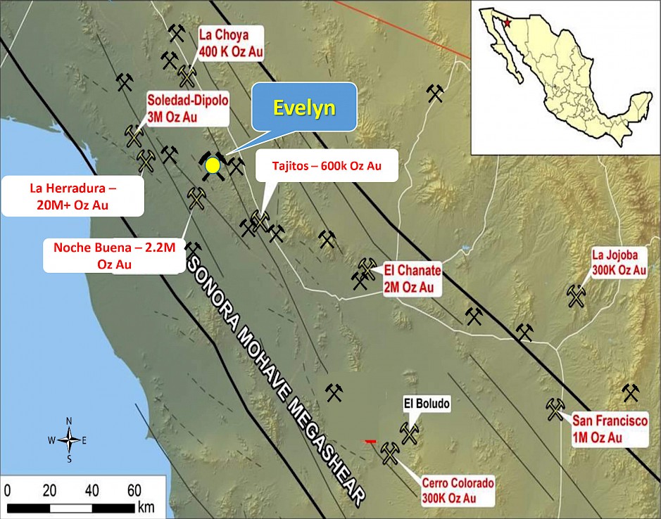
Dieppe, New Brunswick–(Newsfile Corp. – October 27, 2022) – Colibri Resource Corporation (TSXV: CBI) (OTC Pink: CRUCF) (“Colibri” or the “Company”) is pleased to report that the Company has resumed exploration at the Evelyn Gold Property. Company geologists have recently mobilized to the property and are currently collecting soil samples. The Company is also pleased to report that on October 10th, applications for drilling and trenching permits at the Evelyn property were submitted to SEMARNAT (the Mexican government environmental authority). Approvals for this work are expected shortly.
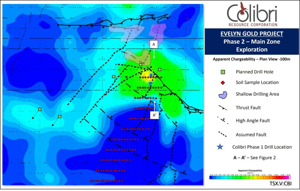
Upon receipt of the drill permit, the Company intends to complete 2 drill programs. The first program will be following up on the Company’s Phase 1 reverse circulation (“RC”) drilling program completed in the fall/winter of 2021/2022 will include a planned 2,000 metres (“m”) in 5 holes designed to test the results of the Induced Polarization (“IP”) Survey completed in 2021. The primary target is a chargeability anomaly that underlies the Main Zone, and the program will include testing a chargeability and resistivity target west of the Main Zone. The locations of the holes planned to test the IP results are indicated in Figure 1.
The second drill program is planned to explore under extensive alluvial cover north of the Main Zone and will comprise drilling a number of short, relatively closely spaced RC holes designed to penetrate the alluvium and sample the top of bedrock. The objective of this program is to locate the northern extension of the Main Zone and to test for the location of other potentially mineralized structures interpreted by the Company. The locations of the areas planned for drill testing bedrock covered by alluvium are indicated in Figure 1.
The soil sampling currently in progress has been designed to test for the southern extension of the Main Zone structure under an apron of relatively thick colluvium and will consist of a Soil Gas Hydrocarbon (“SGH”) program with analyses and interpretation being completed at Activation Laboratories Ltd. (“Actlabs”) located in Ancaster, Ontario. The planned locations of the soil samples being collected are indicated on Figure 1.
Upon receipt of the permit to excavate trenches, the Company will complete a series of trenches across the West Sahuaro target. The West Sahuaro target is based on a discrete soil anomaly whose location and orientation is coincident with a strong resistivity gradient evident in the 2021 IP survey results.
To view an enhanced version of Figure 1, please visit:
https://images.newsfilecorp.com/files/4269/142130_de86803674d53a05_001full.jpg
MAIN ZONE EXPLORATION AND PLAN
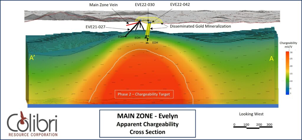
The Main Zone mineralization occurs as a quartz vein that is discontinuously exposed over a strike length of approximately 120 m. The quartz vein pinches and swells along the strike length on surface reaching a maximum exposed thickness of approximately 1.5 m. Grab samples from surface exposures of the vein have returned assay values of 43.9 g/t Au and 40.1 g/t Au. During Phase 1 RC drilling at Evelyn, the Company completed a total of 872 m in 6 holes at the Main Zone. Four of the holes were directed at the Main Zone vein and two of the holes were drilled in the footwall of the Main Zone vein in a direction away from the Main Zone vein. Highlights of the Main Zone vein drilling include 12.19 g/t Au over an intersection length of 3 m which includes an assay of 30 g/t Au over 1 m in hole EVE21-027 and an intersection of 3.28 g/t Au over an intersection length of 2 m in hole EVE22-029. Hole EVE22-030 was drilled in the footwall of the Main Zone vein and intersected 87 m at an average grade of 0.127 g/t Au including 8 m at an average grade of 0.336 g/t Au. Planned to reach a target depth of 250 metres, Hole EVE22-030 was lost due to drilling conditions at a depth of 129 m. Hole EVE22-042 was drilled beside EVE22-030 as an attempt to extend the hole to the target depth of 250 m. The hole intersected multiple zones of mineralization including 0.165 g/t Au over an intersection length of 86 m which included an intersection of 0.551 g/t Au over 10 m. EVE22-042 did not reach target depth as it was also abandoned due to drilling conditions at 177 m. An assay of 0.374 g/t Au over an interval of 1 m was returned from a sample at 174 m depth: 4 m from the end of the hole. Complete Phase 1 drilling results from the Main Zone are contained in the table below.
| Hole ID | From | To | Length | Au gpt | Cutoff |
| EVE21-026 | 3 | 7 | 4 | 0.257 | .1 g/t Au |
| includes | 3 | 4 | 1 | 0.446 | .2 g/t Au |
| EVE21-026 | 65 | 66 | 1 | 0.237 | .2 g/t Au |
| EVE21-026 | 64 | 79 | 15 | 0.196 | .1 g/t Au |
| includes | 72 | 77 | 5 | 0.412 | .2 g/t Au |
| EVE21-027 | 12 | 13 | 1 | 0.322 | .2 g/t Au |
| EVE21-027 | 32 | 46 | 14 | 2.818 | .1 g/t Au |
| includes | 38 | 46 | 8 | 4.823 | .2 g/t Au |
| includes | 41 | 44 | 3 | 12.19 | 3 g/t Au |
| includes | 42 | 43 | 1 | 30 | 5 g/t Au |
| EVE21-027 | 55 | 56 | 1 | 0.287 | .2 g/t Au |
| EVE21-027 | 99 | 100 | 1 | 0.204 | .2 g/t Au |
| EVE22-028 | 24 | 43 | 19 | 0.129 | .1 g/t Au |
| includes | 37 | 43 | 6 | 0.182 | .2 g/t Au |
| EVE22-028 | 55 | 57 | 2 | 0.115 | .1 g/t Au |
| EVE22-028 | 73 | 76 | 3 | 0.240 | .1 g/t Au |
| EVE22-028 | 83 | 84 | 1 | 0.293 | .2 g/t Au |
| EVE22-028 | 117 | 118 | 1 | 0.295 | .2 g/t Au |
| EVE22-029 | 36 | 41 | 5 | 1.393 | .2 g/t Au |
| includes | 36 | 38 | 2 | 3.275 | .2 g/t Au |
| EVE22-029 | 122 | 125 | 3 | 0.337 | .2 g/t Au |
| EVE22-029 | 129 | 131 | 2 | 0.160 | .1 g/t Au |
| EVE22-030 | 25 | 112 | 87 | 0.127 | .1 g/t Au |
| includes | 24 | 49 | 25 | 0.201 | .1 g/t Au |
| includes | 25 | 43 | 18 | 0.230 | .1 g/t Au |
| includes | 28 | 36 | 8 | 0.336 | .2 g/t Au |
| includes | 101 | 106 | 5 | 0.215 | .2 g/t Au |
| EVE22-042 | 19 | 105 | 86 | 0.165 | .1 g/t Au |
| includes | 19 | 41 | 22 | 0.316 | .1 g/t Au |
| includes | 22 | 32 | 10 | 0.551 | .2 g/t Au |
| includes | 60 | 68 | 8 | 0.184 | .1 g/t Au |
| includes | 100 | 105 | 5 | 0.232 | .1 g/t Au |
| EVE22-042 | 125 | 131 | 6 | 0.178 | .1 g/t Au |
| EVE22-042 | 173 | 174 | 1 | 0.324 | .2 g/t Au |
Note: Reported lengths for all holes are intersection lengths. True widths are not known.
The Main Zone mineralization, including mineralization intersected in holes EVE22-030 and EVE22-042 directly overlies a discrete Induced Polarization (“IP”) chargeability anomaly (Figures 1 and 2). The chargeability anomaly is coincident with an apparent resistivity anomaly and is most strongly developed at a depth greater than 200 m (Figure 2). The exploration model relates Main Zone mineralization, exposed on surface and intersected in Phase 1 drilling, to an altered rock body with elevated disseminated sulphide at depth which is controlled by the intersection of the northeast and northwest structures. Phase 2 drilling is planned in the near term to test this model to a depth of at least 500 metres. (Figure 2). In addition, 2 holes are planned to test a weaker IP anomaly on the flank of a resistive high west of the Main Zone.
To view an enhanced version of Figure 2, please visit:
https://images.newsfilecorp.com/files/4269/142130_de86803674d53a05_002full.jpg
WEST EL SAHUARO TARGET EXPLORATION AND PLAN
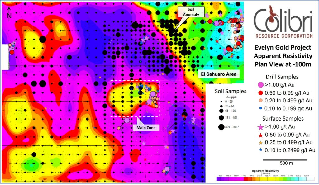
El Sahuaro Zone is located in the northeastern part of the property and is characterized by north-northeast trending magnetic anomalies. Detailed structural mapping in the northeast part of the property indicates a dominant north-northwestern strike and easterly dip to foliation and veins. The structural orientations observed are consistent with north-northwest trending structures interpreted from magnetic intensity contrasts and an apparent dislocation and offset of the north-northeastern magnetic trend. The El Sahuaro area is underlain by Jurassic rhyolite and andesite and by Proterozoic (?) metasedimentary rocks. All holes drilled at El Sahuaro have intersected Au mineralization. Highlights of Phase 1 drilling at El Sahuaro include: (also see Figure 3 below)
EVE21-025 – 0.172 g/t Au over an intersection length of 22 m.
EVE21-018 – 0.103 g.t Au over an intersection length of 25 m.
EVE21-019 – 2.36 g/t Au over an intersection length of 15 m.
EVE22-043 – 0.92 g/t Au over an intersection length of 3 m.
EVE22-044 – 0.627 g/t Au over an intersection length 6 m.
EVE22-046 – 1.943 g/t Au over an intersection length of 2 m and 0.51 g/t Au over an intersection length of 4 m.
West of El Sahuaro zone, a sharp north-northwest trending gradient in apparent resistivity (Figure 3) is interpreted as a fault zone that separates dominantly rhyolite to the southwest with a mixed succession of rhyolite and andesite with Proterozoic metamorphic rocks to the northeast.
To further explore the interpretation of apparent resistivity, the Company completed in-fill soil sampling of the historical soil geochemistry survey which resulted in a coherent soil anomaly over an approximately 500 m length and 200 m width with a north-northwest trend: parallel to the resistivity gradient (Figure 3). Anomalous soil samples in the anomaly area are interpreted to be locally derived and include an assay of 1.5 g/t Au.
The model being explored by the Company relates mineralization intersected in Phase 1 drilling at El Sahuaro, and the Au soil anomaly, to a major controlling structure indicated by the apparent resistivity gradient. Trenches currently being permitted will be excavated over the soil anomaly with the objective of advancing he target to the drill stage.
To view an enhanced version of Figure 3, please visit:
https://images.newsfilecorp.com/files/4269/142130_de86803674d53a05_003full.jpg
ABOUT SGH
SGH is a deep penetrating geochemical exploration method that involves the analysis of surficial samples from over potential (buried) mineral or petroleum targets. The analysis involves the testing for 162 hydrocarbon compounds in the C5-C17 carbon series range applicable to a wide variety of sample types. Samples are collected in the target area in a systematic manner generally at sample stations spaced at 25 m along 100 m spaced lines. Actlabs has developed an in-depth understanding of the unique SGH signatures associated with different commodity targets. Using a forensic approach based on scientific research, orientation surveys over known (buried) mineralization, and the results of exploration projects, Actlabs has developed commodity target signatures, or templates, for identification of the expected analytical results exhibited by each class of SGH compounds.
EVELYN GEOLOGY AND EXPLORATION
The Evelyn Gold Project is an Orogenic-type gold target located in the Caborca Gold Belt of northwestern Sonora. The property is located approximately 25 kilometres (“km”) east of La Herradura, Mexico’s largest open pit gold mine, which produced 425,288 ounces of gold in 2020 at an average grade of 0.77 grams per tonnes (“g/t”) Au and is also approximately 9 km northeast of the Noche Buena mine which produced 87,988 ounces Au at an average grade of 0.52 g/t Au in 2020. The setting and style of mineralization at Evelyn is similar to that reported from La Herradura and Noche Buena. Higher grade mineralization on the Evelyn property consists of quartz veins and veinlets, ranging from 2 – 3 centimeters up to 1.5 m hosted by fault and fracture zones with minor oxidized pyrite, iron oxide, copper bearing oxide and carbonate minerals, and locally minor to trace amounts of galena, chalcopyrite, and sphalerite. Alteration of the host rocks includes iron bearing carbonate minerals, quartz, sericite, and chlorite. Lower grade mineralization is associated with altered volcanic rocks containing minor amounts of oxidized sulfide. Mineralization is hosted dominantly by Jurassic volcanic rocks consisting of andesite and rhyolite.
The exploration model being developed and tested by the Company relates the mineralization consisting of higher-grade veins and veinlets hosted by altered and sulphide bearing lower grade metamorphic and volcanic rocks, to north-northeast trending stratigraphy and layer-parallel fault zones and southeast striking, moderately southwest dipping fault zones.
QUALIFIED PERSON
Jamie Lavigne, P. Geo and a Director for Colibri is a Qualified Person as defined in NI 43-101 and has reviewed and approved the technical information in this press release.
ABOUT COLIBRI RESOURCE CORPORATION:
Colibri is a Canadian-based mineral exploration company listed on the TSX-V (CBI) and is focused on acquiring and exploring prospective gold & silver properties in Mexico. The Company has six exploration projects of which five currently have exploration programs being executed 2021 and 2022. (1) The flagship Evelyn Gold Project is 100% owned and explored by Colibri, (2) the Pilar Gold & Silver Project (optioned to Tocvan Ventures – (CSE: TOC)), (3) the El Mezquite Gold & Silver Project , (4) the Jackie Gold & Silver Project, and (5) the Diamante Gold & Silver Project. 3, 4, and 5 are subject to earn-in agreements by Silver Spruce Resources – (TSXV: SSE).
For more information about all Company projects please visit: http://www.colibriresource.com/.
Neither TSX Venture Exchange nor its Regulation Services Provider (as that term is defined in the policies of the TSX Venture Exchange) accepts responsibility for the adequacy or accuracy of this release.
Notice Regarding Forward-Looking Statements:
This news release contains “forward-looking statements”. Statements in this press release which are not purely historical are forward-looking statements and include any statements regarding beliefs, plans, expectations or intentions regarding the future. Actual results could differ from those projected in any forward-looking statements due to numerous factors. These forward-looking statements are made as of the date of this news release, and the Company assumes no obligation to update the forward-looking statements, or to update the reasons why actual results could differ from those projected in the forward-looking statements. Although the Company believes that the plans, expectations and intentions contained in this press release are reasonable, there can be no assurance that they will prove to be accurate.
For information contact: Ronald J. Goguen, President, Chairperson and Director, Tel: (506) 383-4274, [email protected]
Original Article: https://www.newsfilecorp.com/release/142130


