
Vancouver, British Columbia – October 6, 2020 – Brigadier Gold Limited (the “Company” or “Brigadier”) (TSXV: BRG, FSE: B7LM) is pleased to announce results from recent sampling of multiple parallel veins which comprise the El Placer vein system at its Picachos gold-silver project, Sinaloa Mexico.
Highlights:
- El Placer vein system has now been traced for over 4 kilometres
- Sample
assay highlights include:
- 7.4 grams per ton (g/t) gold over 3.2 metres;
- 12.8 g/t gold, 54 g/t silver, 0.1% copper, 7.7% lead, and 6.73% zinc over 0.5 metres; and
- 101 g/t silver, 0.3% copper, 2% Lead, 11.6% zinc over 1 metre.
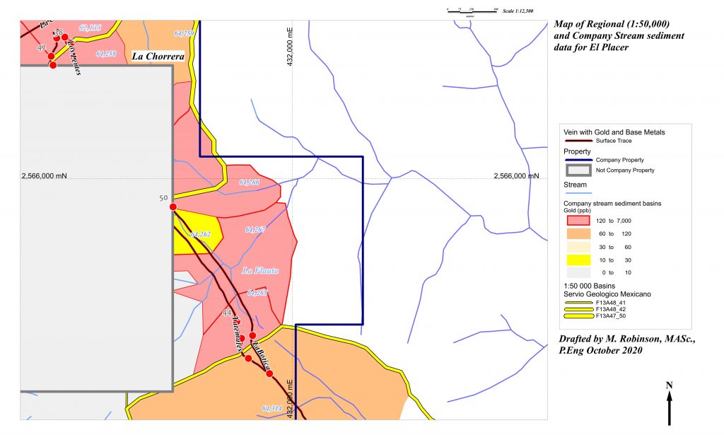
- Stream sediment samples indicate highly anomalous gold and strong base metals
Three Government (Servicio Geologico Mexicano; SGM) stream sediment samples taken downstream of El Placer sample define an area 1259 hectares in size that includes ground east of the Property. A maximum value of 2.6 parts per million (ppm) gold is reported. Company samples are from smaller basins ranging from 91 to 14 hectares in size. The maximum value of 6.8 ppm gold is from a 33 hectare basin downstream of La Boticaa Vein (sample 64266). Both Government and Company data sets indicate very anomalous gold, strong base metals and subdued silver.
Michelle Robinson, QP, comments “The significance of these results cannot be overstated. I have compiled the 1:50 000 SGM data underlying other important gold discoveries in Mexico. For example, the Amalia discovery made by Radius Gold and optioned by Pan-American Silver was indicated by single sample G13C13-101 with an area of 186 hectares and values of 0.06 ppm gold and silver below the detection limit of the analytical method used by the SGM.”
Ranjeet Sundher, CEO, comments “We’re highly encouraged as Michelle and her team, driven by their intimate knowledge of Picachos, continue to bolster their understanding of the extensive vein systems surrounding the historic high grade San Agustin gold-silver mine. Our current 5,000 meter drill program is targeting several high priority veins under and around San Agustin for the first time in the project’s history. This latest round of sampling underscores our thesis that Picachos may host a district scale mineralized system not unlike those discovered approximately 15 miles to the north and south of us.”
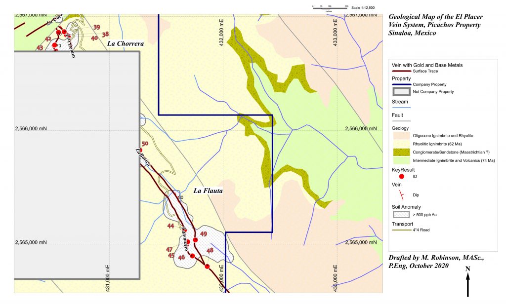
The El Placer Vein system has been mapped on surface over a strike length of 4 kilometres on the western flank of the Río Baluarte watershed. There are several near-parallel veins within the system over a trend width ranging from 60 to 160 metres. The major structure is the Tatemales Vein with an average dip of 68° degrees towards azimuth 47° (northeast). La Botica dips 68° towards 57° (northeasterly) and intersects with Tatemales in the vicinity of La Flauta. Los Lentes occurs between Tatemales and La Botica, and dips 60° towards azimuth 246° (southwest). The Company has the mineral rights to two portions of the El Placer Vein system. The largest portion is in the southeast part of the Property and has a 1400 metre long strike between Property held by Fresñillo PLC to the northwest, and Property held by an individual to the southeast. The Company calls this area La Flauta as a southeasterly facing view of the historic workings look like the keys on a flute. Structural fault damage between Tatemales and La Botica is extensive and stockwork zones are developed between these major veins. The other portion owned by the Company has been defined over a 300 metre strike length northwest of Fresñillo’s Property. This area is called La Chorrera, and it includes La Chivera underground workings on the Tatemales Vein and Los Lentes underground workings on Los Lentes Vein. Key analytical results are in Table 1 and located on the Map.
Table 1. Key results from the El Placer Vein
| ID | Vein | Result | Width (m) | Sample(s) |
| 38 | Los Lentes | 7.4 g/t Au, 0.2% Pb | 3.2 | 27431, 27432 |
| 39 | Los Lentes | 1.6 g/t Au, 0.1% Pb, 0.2% Zn | 3.0 | 23782, 23783, 23784 |
| 40 | Los Lentes | 2.7 g/t Au, 0.3% Pb, 0.3% Zn | 1.1 | 23782 |
| 41 | Tatemales | 8.9 g/t Au, 7 g/t Ag, 0.1% Cu, 0.2% Pb, 0.2% Zn | 1.0 | 23877 |
| 42 | Tatemales | 2 g/t Au, 0.1% Pb, 0.3% Zn | 0.8 | 23787 |
| 43 | Tatemales | 101 g/t Ag, 0.3% Cu, 2% Pb, 11.6% Zn | 1.0 | 23367 |
| 44 | Tatemales | 33 g/t Au, 24 g/t Ag, 0.1% Cu, 1% Pb, 3.4% Zn | 0.7 | 27499 |
| 45 | Tatemales | 4.6 g/t Au, 90 g/t Ag, 0.2% Cu, 2.1% Pb, 1.6% Zn | 5.4 | 27484, 27485, 27486 |
| 46 | Tatemales | 11.7 g/t Au, 14 g/t Ag, 0.2% Pb, 0.4% Zn | 1.9 | 27472, 27473 |
| 47 | Tatemales | 13.4 g/t Au, 333 g/t Ag, 1.3% Cu, 0.4% Pb, 2.5% Zn | 0.7 | 27488 |
| 48 | Tatemales | 8.2 g/t Au, 178 g/t Ag, 0.1% Cu, >1% Pb, >1% Zn | 2.0 | 18511 |
| 49 | La Botica | 12.8 g/t Au, 54 g/t Ag, 0.1% Cu, 7.7% Pb, 6.73% Zn | 0.5 | 27463 |
| 50 | La Botica | 8.7 g/t Au, 15 g/t Ag, 0.2% Cu, 0.1% Pb, 0.1% Zn | 1.0 | 25177 |
Principal host rocks to the mineralization are rhyolitic lapillistones that were mapped as part of the Oligocene volcanic field that extends from Chihuahua to Jalisco State by the Servicio Geólogico Mexicano. The Company submitted a sample of rhyolitic tuff to the University of Arizona under the supervision of Dr. Martín Valencia of the Universidad Nacional Autónoma de Mexico for radiometric dating of zircons within the tuff. The age determination yielded a Paleocene (Danian) age of about 62 million years. This age is similar to the Productive volcanic series at Tayoltita mentioned in the work of Montoya-Lopera et al. (2019). The rhyolitic tuffs are intruded by a mineralized alkali granite dike that follows the same northwesterly trending structure as the Tatemales Vein.
Mineralization consists of microcrystalline quartz breccias, veins and veinlets with selvedges of chlorite that appears to have formed from retrograde alteration of biotite or another iron-rich mica. Apatite occurs in some locations on the Botica Vein at La Flauta. Hypogene sulfides are mainly sphalerite and galena, but these are mainly oxidized to willemite and anglesite on surface and near-surface underground exposures. Late quartz is typically comb and may or may not be intergrown with base metal sulfides.
Regional Context
Table 2. Results for Government stream sediment samples from creeks that drain El Placer (data from the Servicio Geologico Mexicano).
| Sample | Area (Ha) | Au (ppm) | Ag (ppm) | Cu (ppm) | Pb (ppm) | Zn (ppm) |
| F13A48_41 | 839 | 0.14 | DL | 79 | 271 | 655 |
| F13A48_42 | 307 | 1.41 | DL | 66 | 509 | 586 |
| F13A47_50 | 113 | 2.60 | 1 | 299 | 639 | 1716 |
Table 3. Results for Company stream sediment samples from creeks that drain mainly the Company’s part of El Placer.
| SAMPLE | Area (Ha) | Au (ppm) | Ag (ppm) | Cu (ppm) | Pb (ppm) | Zn (ppm) |
| 64135 | 78 | 0.65 | DL | 43 | 115 | 197 |
| 64258 | 27 | 1.43 | 0.7 | 201 | 661 | 1300 |
| 64259 | 24 | 0.06 | DL | 8 | 93 | 243 |
| 64262 | 25 | 0.03 | DL | 40 | 107 | 189 |
| 64265 | 14 | 2.28 | 2.1 | 589 | 3417 | 2165 |
| 64266 | 33 | 6.84 | 0.9 | 102 | 411 | 664 |
| 64267 | 35 | 0.27 | DL | 52 | 351 | 239 |
| 64314 | 91 | 0.08 | DL | 21 | 158 | 164 |
Reference
Montoya-Lopera, P., Ferrari, L., Levresse, G., Abdullinb, F., Mata, L. (2019) New insights into the geology and tectonics of the San Dimas mining district, Sierra Madre Occidental, Mexico; Ore Geology Reviews 105: 273–294
Picachos is comprised of four mining concessions covering an area of 3,954 hectares and is situated in the municipality of El Rosario, in the southeastern region of Sinaloa state, Mexico. Geographically, Picachos overlaps part of the western foothills of the Sierra Madre Occidental (SMO). Picachos can be accessed from Mazatlán by state highway and paved road to the town of Cacalotán, and then by country road into the Property. Total driving distance is approximately 111 road-kilometres over a period of four hours. Mine workings are accessed by approximately 20 kilometres of roads internal to the Property.
The Company has not undertaken any independent investigation of the historical information contained in this press release nor has it independently analyzed the results of the previous exploration work in order to verify the accuracy of the information. The Company believes that the historical results and other information contained in this press release are relevant to continuing exploration on the Property.
Qualified Person
Technical information in this press release has been reviewed by Michelle Robinson, MASc., P.Eng., a Qualified Person (“QP”) as defined by NI-43-101. The analytical methods used for rock chip channel samples and SGM as well as Company stream sediment samples are discussed in detail at the end of the Company’s press release dated September 14, 2020. It is the QP’s opinion that the results disclosed in this press release are reliable.
About Brigadier Gold Limited
Brigadier was formed to leverage the next major bull market in the natural resource sector, particularly precious metals. Our mandate is to acquire undervalued and overlooked projects with demonstrable potential for advancement.
Led by a management team with decades of experience in mineral exploration and capital markets development, we are focused on advanced exploration opportunities in politically stable jurisdictions.
For further information, please contact:
Brigadier Gold Limited
www.brigadiergold.ca
Ranjeet Sundher, Chief Executive Officer
[email protected]
Leah Hodges, Corporate Secretary
(604) 377-0403
Reader Advisory
This news release may contain statements which constitute “forward-looking information”, including statements regarding the plans, intentions, beliefs and current expectations of the Company, its directors, or its officers with respect to the future business activities of the Company. The words “may”, “would”, “could”, “will”, “intend”, “plan”, “anticipate”, “believe”, “estimate”, “expect” and similar expressions, as they relate to the Company, or its management, are intended to identify such forward-looking statements. Investors are cautioned that any such forward-looking statements are not guarantees of future business activities and involve risks and uncertainties, and that the Company’s future business activities may differ materially from those in the forward-looking statements as a result of various factors, including, but not limited to, fluctuations in market prices, successes of the operations of the Company, continued availability of capital and financing and general economic, market or business conditions. There can be no assurances that such information will prove accurate and, therefore, readers are advised to rely on their own evaluation of such uncertainties. The Company does not assume any obligation to update any forward-looking information except as required under the applicable securities laws.
Neither the TSX Venture Exchange nor the Investment Industry Regulatory Organization of Canada accepts responsibility for the adequacy or accuracy of this release.


