Drilling and Surface Sampling Results Indicate Primary Vein System Contains Over 7 Kilometres of Robust Mineralization
Drill Assay Results from Other Previously Untested Prospective Zones Expected During January
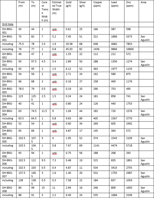
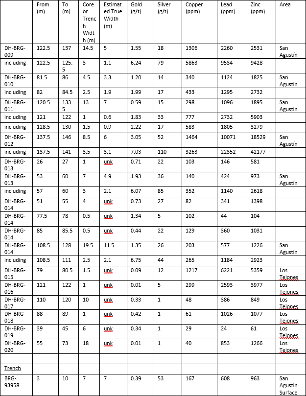
Vancouver, British Columbia – January 19, 2021 – Brigadier Gold Limited (the “Company” or “Brigadier”) (TSXV: BRG|FSE: B7LM|USA: BGADF) is pleased to provide additional diamond drill and surface sampling results from ongoing phase one exploration at its Picachos gold-silver project, Sinaloa Mexico (the “Picachos Project” or the “Property”). Brigadier has completed 3085 metres of diamond drilling in 28 holes on the Picachos Project. Assays are now available for 20 holes (Table 1), and samples from the remaining holes are in-progress at SGS Laboratory in Durango.
Drilling highlights include:
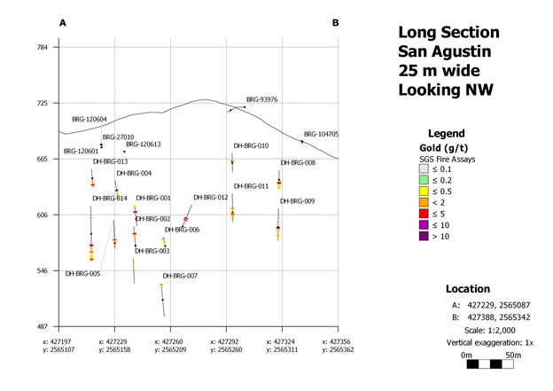
- 9.49 g/t Au and 24 g/t Ag across 3 m (88 to 91 m) in DH-BRG-008
- 6.24 g/t Au and 79 g/t Ag across 3 m (122.5 to 125.5 m) in DH-BRG-009
- 7.03 g/t Au and 110 g/t Ag across 3.5 m (137.5 to 141 m) in DH-BRG-012
- 6.75 g/t Au and 44 g/t Ag across 2.5 m (108.5 to 111 m) in DH-BRG-014
Geologist and Qualified Person Michelle Robinson comments “I am really pleased with our results so far from San Agustín. The structure is persistent and strongly mineralized. Although our sampling with a diamond drill is not perfect due to the challenging sub-surface conditions, it definitely indicates a robust gold-bearing vein of substantial width and strike length of over seven kilometers. I look forward to expanding the depth and strike length in 2021, as well as continuing the exploration of the rest of the CVS (Colomeca Vein System), particularly in the central Cocolmeca area where a swarm of northwesterly trending veins intersects the east-north-easterly trending Cocolmeca Vein System.”
Ranjeet Sundher, President and CEO, also comments “We are impressed with the speed in which Michelle and her team is de-risking the Picachos Project and increasingly demonstrating its regional scale potential. With just a small portion of the asset explored to date, I’m looking forward to keeping shareholders abreast as we aggressively move forward to further define the Colomeca Vein System while also commencing examination of the large copper-molybdenum porphyry target located on the northern part of the Property.”
Of the 28 holes drilled to date, fourteen (1704.28 metres) were drilled to test the San Agustín Vein, 10 holes (1029 metres) tested surface exploration targets defined by trenching, 2 holes (168.5 metres) tested under the historic San Antoñio Mine and one hole tested under the historic La Gloria Mine. San Agustín and San Antoñio represent two gold-rich, polymetallic mineral chutes about 2.5 kilometres apart on Brigadier’s regional-scale Cocolmeca Vein System (CVS), and La Gloria historically produced gold from a northwesterly trending vein roughly orthogonal to the CVS. The CVS has been defined at varying levels of certainty along the east-northeasterly trending diagonal of the Picachos Project for more than seven kilometres. Six surface rock chip-channel results that help define the location of the CVS include:
- 4.89 g/t Au and 67 g/t Ag across 5 metres (trench BRG-104705) from San Agustín (PR dated 24 November 2020)
- 1.85 g/t Au and 4 g/t Ag across 10 metres (trench BRG-120920) at Los Tejones prospect pits, centered 1 kilometre northeast of San Agustín
- 347 g/t Ag, 0.1 g/t Au and 5.2% Cu across 1.0 metres (historic trench MTA-15953) at Guayabo, 2.4 kilometres northeast of San Agustín
- 44.09 g/t Au and 47 g/t Ag across 0.8 metres (historic trench MTA-19856) at San Antoñio, 2.5 kilometres northeast of San Agustín
- 5.25 g/t Au and 74 g/t Ag across 1.2 metres (trench BRG-27012) from the road to La Botica, 3.7 kilometres from San Agustín
- 1.9 g/t Au and 98 g/t Ag across 1.6 metres (trench BRG-25220) from El Pino, 5.8 kilometres northeast of San Agustín (PR dated 14 September 2020)
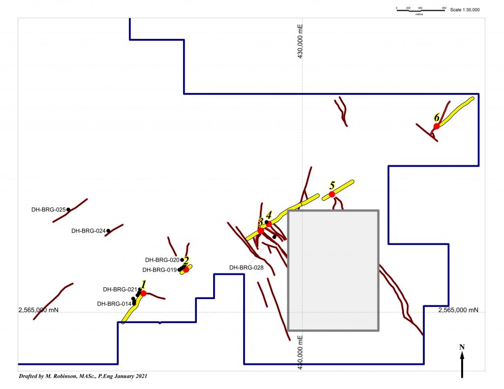
During the Fall of 2020, the Company primarily explored the down-dip potential of the southwestern most segment of the CVS that was historically exploited by Minas de Picacho from San Agustín Adit Level 646 in the 1990’s. Three fences of holes were drilled up to 130 metres north of this adit, and three fences were drilled up to 90 metres south of Level 646. Overall, a strike length of about 210 metres was tested. Most mineral intercepts were located between 650 and 550 metres elevation. The deepest test was in DH-BRG-007 at 530 m elevation or 200 metres below topography.
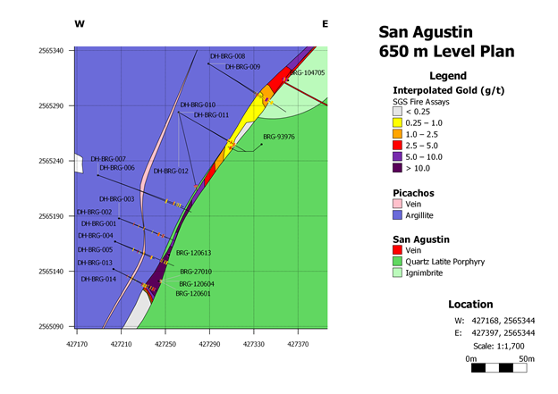
Geologically, the mineralization is located at the faulted and sheared contact between metamorphosed, thickly laminated, sulfide-rich argillite of deep marine origin and porphyritic intermediate continental volcanic rocks correlated to the Tarahumara Formation. Fault damage on this regional-scale geological terrane boundary is profound with shearing and quartz veining evident at several locations in the hanging wall to the San Agustín Vein. On Figure 3, a preliminary interpretation of what this veining might look like is shown in the rose color in the Picachos Project fault block. Some results from quartz veins and veinlets in the hanging wall to the San Agustín Vein are:
- 2.71 g/t Au and 24 g/t Ag across 2 m (54 to 56 m) in DH-BRG-003
- 0.6 g/t Au and 34 g/t Ag across 2 m (52 to 54 m) in DH-BRG-005
- 0.73 g/t Au and 27 g/t Ag across 4 m (51 to 55 m) in DH-BRG-014
At Los Tejones, encouraging results of 1.85 g/t Au were cut across 10 meters in a surface trench (BRG-120920). About 50 meters to the northeast, a second trench cut 1 meter of 428 g/t Ag (BRG-119913). Rock discovered by both trenches was deeply weathered and structures controlling the mineralization were mostly not obvious. Drill testing under these anomalies returned anomalous base metals but subdued precious metals (DH-BRG-015 to 20). Geologically, disseminated and stockwork mineralization occurs at the faulted contact between magnetic andesitic volcanics that might be Jurassic in age, and intermediate volcanic rocks correlated to the Tarahumara Formation.
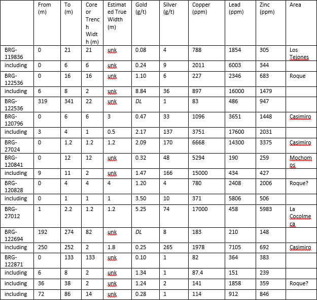
Results from other surface trenches include:
- 2.09 g/t Au and 170 g/t Ag across 1.2 m from the Casimiro Vein (BRG-27024)
- 8.84 g/t Au, 36 g/t Ag and 1.6% Pb across 2 m from El Roque Vein (BRG-120828)
- 5.25 g/t Au, 74 g/t Ag and 1.7% Cu across 1.2 m from La Cocolmeca Vein (BRG-27012)
Table 1. List of results from drill holes and trenches completed by the Company in the fall of 2020.

The Picachos Project land package was methodically assembled by Michelle Robinson (MASc., P.Eng., Geologist, 43-101 QP) over 10 years ago. Michelle is a respected industry veteran who has worked in Mexico for over 20-years with a number of major mining companies. She has authored over 20 technical reports and published several papers for the Society of Economic Geologists. Michelle and her team are executing on our 5,000-metre diamond drill program – the first ever on this project
The Picachos Project’s location, situated 25 kilometres equidistant from two recent bonanza grade discoveries of Vizsla Resources and GR Silver and along the same mineralized trend, positions Picachos Project as a truly exciting opportunity for Brigadier and our shareholders.
The 3,954 hectare Picachos Project is centered over the historic “Viva Zapata” National Mineral Reserve, Sinaloa, Mexico. It overlaps two mineralized systems, a porphyry copper-molybdenum system hosted by a Paleocene granite-granodiorite intrusive complex, and a gold-silver vein complex comprised of both east-northeasterly trending veins (La Cocolmeca Vein System) and northwesterly trending veins (El Placer System). Sericitic alteration related to the porphyry system has been mapped over the northwestern two-thirds of the Property. Quartz-biotite veinlets with chalcopyrite and bornite occur in the central part of this broad zone of sericitic alteration and imply the presence of a significant porphyry system at depth. La Colcomeca Vein system has been mapped from San Agustín Underground Gold Mine in the southwestern part of the Property to El Pino seven kilometres to the northeast. In the central part of the Property, the best exposure of the northwesterly trending system occurs between La Gloria Underground Gold Mine and the Urrea Gold Mines, located 630 metres southwest of La Gloria. In this area, other northwesterly trending veins between these veins include Paldodismo, Colorin, Salvador, Trompetas and Mangos. On the eastern part of the Property, Tatemales and La Botica define a four kilometre long trend.
The growing inventory of priority drill targets underscore the untapped potential of this particular region of Sierra Madre Occidental epithermal belt.
Please visit our website to learn more about Brigadier
Gold.
National Instrument 43-101 Disclosure
The technical information in this press release has been reviewed by Michelle Robinson, MASc., P.Eng., a Qualified Person as defined by National Instrument 43-101 – Standards of Disclosure for Mineral Projects (“NI 43-101”). Core and sample handling procedures are documented in the Company’s press release dated October 22, 2020. Standard pulps, field duplicates, pulp duplicates and blanks are inserted into the sample stream. The samples were analyzed by SGS Laboratories in Durango using fire-assay methods for gold, and ICP methods with a 4-acid digestion for silver and base metals. SGS is an accredited laboratory. It is the QP’s opinion that the technical information disclosed in this press release is reliable.
About Brigadier Gold Limited
Brigadier was formed to leverage the next major bull market in the natural resource sector, particularly precious metals. Our mandate is to acquire undervalued and overlooked projects with demonstrable potential for advancement.
Led by a management team with decades of experience in mineral exploration and capital markets development, we are focused on advanced exploration opportunities in politically stable jurisdictions.
For further information, please contact:
Brigadier Gold Limited
www.brigadiergold.ca
Ranjeet Sundher, Chief Executive Officer
[email protected]
Leah Hodges, Corporate Secretary
(604) 377-0403
Reader Advisory
This news release may contain statements which constitute “forward-looking information”, including statements regarding the plans, intentions, beliefs and current expectations of the Company, its directors, or its officers with respect to the future business activities of the Company. The words “may”, “would”, “could”, “will”, “intend”, “plan”, “anticipate”, “believe”, “estimate”, “expect” and similar expressions, as they relate to the Company, or its management, are intended to identify such forward-looking statements. Investors are cautioned that any such forward-looking statements are not guarantees of future business activities and involve risks and uncertainties, and that the Company’s future business activities may differ materially from those in the forward-looking statements as a result of various factors, including, but not limited to, fluctuations in market prices, successes of the operations of the Company, continued availability of capital and financing and general economic, market or business conditions. There can be no assurances that such information will prove accurate and, therefore, readers are advised to rely on their own evaluation of such uncertainties. The Company does not assume any obligation to update any forward-looking information except as required under the applicable securities laws.
Neither the TSX Venture Exchange nor the Investment Industry Regulatory Organization of Canada accepts responsibility for the adequacy or accuracy of this release.


