Vancouver, British Columbia – September 14, 2020 – Brigadier Gold Limited (the “Company” or “Brigadier”) (TSXV: BRG, FSE: B7LM) is pleased to announce sampling results from Garabato and El Pino, two major vein systems in the northeastern part of the Picachos gold-silver Property, Sinaloa, Mexico (the “Picachos Property”).
The Picachos Property has never been diamond drill tested and boasts over 160 historic workings and mines, which are accessible by more than 20 km of roads internal to the property.
Recent and ongoing bonanza grade discoveries produced by neighbouring explorers to the north (Vizsla Resources) and south (GR Silver Mining) underscore the untapped potential of this particular region of Sierra Madre Occidental epithermal belt.
Ranjeet Sundher, President and CEO, remarks “Significant values include 160 g/t silver across 7 m at Garabato, and 21.3 g/t Au across 1 meter at El Pino. Further work including trenching and soil sampling followed by drilling is clearly warranted.”
Mr. Sundher continues “Brigadier is preparing to initiate a maiden 5,000 metre drill program targeting the high grade historic San Agustin mine and surrounding prospects (see press release dated September 9, 2020) in order to better understand the depth, strike length and continuity of the veins. In addition to the high-grade San Agustin mine, the Picachos Property offers exceptional exploration potential, with over 160 historic mines and workings throughout the property.”
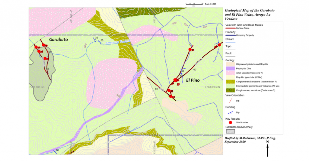
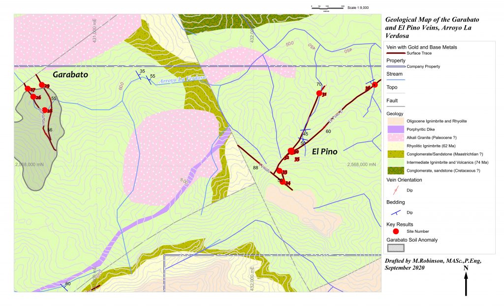
Garabato
The Garabato prospects are in headwaters of the Arroyo La Verdosa, about 1.7 kilometers west of El Pino in the northeastern part of the Picachos Property. This early exploration is limited to a few geological traverses, sparse rock chip-channel samples and a widely spaced soil geochemical grid (100 m * 100 m). Mineralization is mainly in deeply oxidized quartz-sulfide veins with notable concentrations of silver, gold and sometimes copper. Veins are oriented similarly to bedding, and some of the mineralization might be strata-bound on favorable bedding planes. Highlights from in-situ rock chip-channel samples are summarized in Table 1 (locations 26 to 29). The Garabato veins are co-incident with a polymetallic soil geochemical anomaly about 20 Ha in area. Maximum values of 36 ppm silver, 366 ppm copper, 1049 ppm lead and 1184 ppm Zn were determined for soil samples in the Garabato anomaly area.
El Pino
Historic workings at El Pino expose four quartz-sulfide veins hosted mainly in glassy pyroclastic rocks that probably correlate with the Socavon Ignimbrite of the Tarahumara Formation as defined by Montoya-Lopera et al. (2019). Mineralization consists mainly of galena with lesser sphalerite and copper sulfides such as chalcocite, bornite and chalcopyrite. Iron sulfides are mainly pyrrhotite and pyrite. Vein selvedges are altered to celadonite, an iron-rich muscovite. On surface, mineralization is oxidized to copper and lead sulfates such as linarite, brochantite and anglesite. Gold occurs in electrum and is apparent in crushed and panned samples. El Pino West is the largest vein in this group and has been traced out on surface between sample sites 31 and 33 for 650 m over an elevation range of 300 m between 552 meters and 852 meters elevation. Highlights from in-situ rock chip-channel samples are summarized in Table 1 (locations 30 to 36).
Table 1. Surface and underground rock-chip channel geochemical results from veins exposed in the Arroyo La Verdosa, Picachos Project, Sinaloa, Mexico.
| Location ID | Vein | Result | Width (m) |
| 26 | Garabato | 160 g/t Ag, 0.6 g/t Au | 7.0 |
| 27 | Garabato | 205 g/t Ag, 0.2 g/t Au | 3.0 |
| 28 | Garabato | 107 g/t Ag, 0.1 g/t Au, 1.5% Cu | 0.4 |
| 29 | Garabato E | 6.6 g/t Au, 356 g/t Ag | 0.5 |
| 30 | El Pino West | 1.9 g/t Au, 98 g/t Ag, 0.6% Cu, 3.7% Pb, 1.5% Zn | 1.6 |
| 31 | El Pino West | 56.7 g/t Au, 288 g/t Ag, 1.9% Cu, 5.9% Pb, 1.3% Zn | 0.2 |
| 32 | El Pino West (footwall veinlet) | 10.8 g/t Au, 31 g/t Ag, 0.3% Cu, 4.9% Pb, 5.6% Zn | 0.2 |
| 33 | El Pino FW | 21.3 g/t Au, 5 g/t Ag, 3.2% Pb, 0.8% Zn | 1.0 |
| 34 | El Cenido | 2.2 g/t Au, 5 g/t Ag, 0.2% Cu, 0.4% Pb | 0.4 |
| 35 | El Pino East | 0.2 g/t Au, 14 g/t Ag, 0.2% Cu, 0.6% Pb, 0.8% Zn | 3.0 |
| 36 | El Pino East | 0.4 g/t Au | 1.2 |
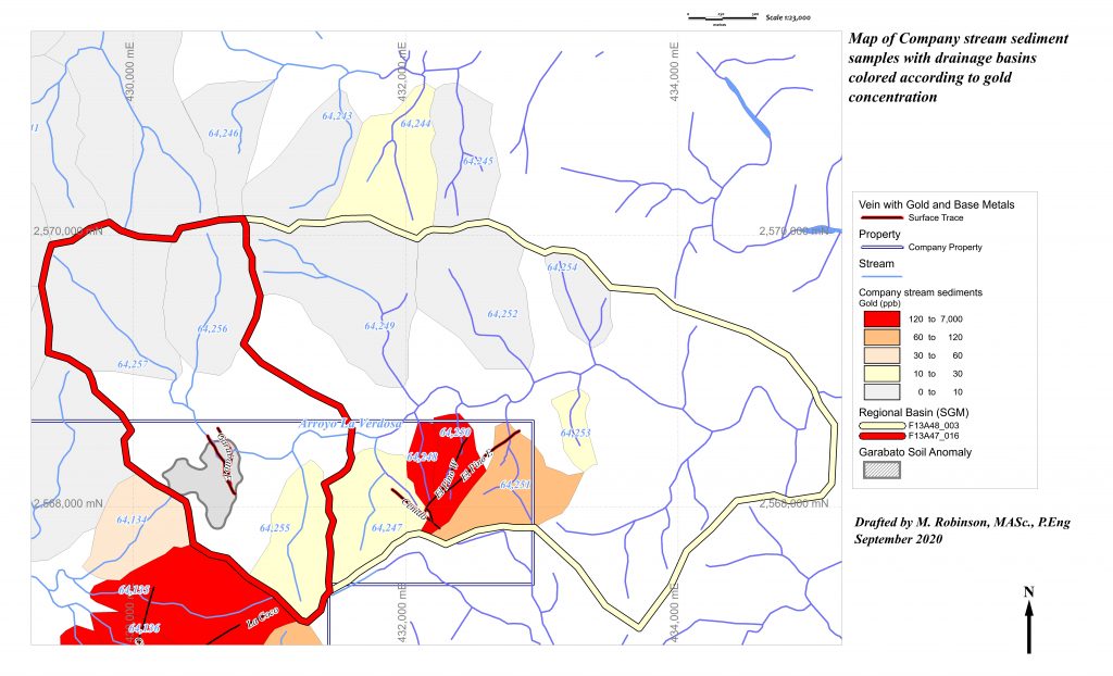
El Pino is located about 3 km upstream of SGM sample site F13A48_003 in the Arroyo La Verdosa. This samples a drainage basin 787 Ha in size with anomalous precious metal values of 1.9 ppm Ag and 21 ppb Au, as well as anomalous base metal values of 49 ppm copper, 83 ppm lead and 141 ppm Zn. Detailed sampling of smaller basins by the Company shows that the source of this anomaly is El Pino. Specifically, Company stream sediment samples from 3 contiguous drainage basins that overlap 76 Ha surrounding the El Pino veins contain markedly anomalous gold and lead concentrations, as well as significant concentrations of other metals (Table 2 and Figure 2). About 1 kilometer downstream of Garabato, the SGM sampled 731 ppb Au, 89 ppm Cu, 3.2 ppm Mo, 76 ppm Pb and 132 ppm Zn in sample F13A47_016, a basin 362 Ha in size. All Company samples in this basin were taken upstream of Garabato, and it was not detected in Company stream sediment data.
Table 1. Metal concentrations in ppm for stream sediments collected from 3 creeks draining El Pino.
| Point | Size (ha) | Ag | Au | Cu | Mo | Pb | Zn |
| MTA-64248 | 10 | 0.9 | 0.1218 | 58.5 | 8 | 597 | 292 |
| MTA-64250 | 22 | 0.6 | 1.7261 | 33.4 | 1.3 | 331.1 | 329 |
| MTA-64251 | 44 | 0.7 | 0.0791 | 33.7 | 5.4 | 126.1 | 215 |
Picachos is comprised of four mining concessions covering an area of 3,954 hectares and is situated in the municipality of El Rosario, in the southeastern region of Sinaloa state, Mexico. Geographically, the Picachos overlaps part of the western foothills of the Sierra Madre Occidental (SMO). Picachos can be accessed from Mazatlan by state highway and paved road to the town of Cacalotan, and then by dirt road into the Picachos Property. Total driving distance is approximately 111 road kilometres (km) over a period of 2.5 hours. Mine workings are accessed by approximately 20 km of roads internal to the Picachos Property.
Reference
Montoya-Lopera, P., Ferrari, L., Levresse, G., Abdullinb, F., Mata, L. (2019) New insights into the geology and tectonics of the San Dimas mining district, Sierra Madre Occidental, Mexico; Ore Geology Reviews 105: 273–294.
National Instrument 43-101 Disclosure
The technical content of this new release has been reviewed and approved by Ms. Michelle Robinson, MASc., P.Eng., and a Qualified Person as defined by National Instrument 43-101.
Underground and surface rock chip-channel samples were cut across oriented structures using a hammer and chisel. Approximately 5 kg of material was collected onto a drop-bag, then rolled and quartered. From this, roughly 2 kg of roughly homogenized rock chips were collected in a double-plastic bag with the numbered tag facing outwards between the bags.
Rock samples were sent either to Acme’s preparation laboratory in Guadalajara, Jalisco, or to SGS Laboratories in Durango. At either lab, the, the samples were crushed and split. A one kg split of each sample was pulverized to -200 mesh. For Acme, prepared pulps were sent to the North Vancouver lab for analysis using ICP-MS methods (code 1DX) and fire assay methods using a gravimetric finish (code Group 6Gr). For SGS, the samples were analyzed in Durango using ICP methods for base metals and silver, and fire assays with either an AA or gravimetric finish. It is Ms. Robinson’s opinion that the geochemical results in Table 1 are reliable.
Soil samples from Garabato were collected by cleaning leaf litter and organics off the sample site, then digging 10 centimeters into mineral soil with a shovel. The sample was taken by loosening the earth using a pointed wooden stake driven into the exposed site with a hammer to loosen up the soil without the use of metal tools. About 0.5 kg of soil was collected in a numbered bag, and the location was recorded in UTM co-ordinates, WGS84 datum on a tablet computer. The samples were scanned for element concentrations with a Niton benchtop XRF at the office in Mazatlán, Sinaloa. It is Ms. Robinson’s opinion that the soil sample anomaly is accurately located on the maps, and that the data are reliable.
Regional geochemical samples F13A48_03 and F13A47_16 were collected from sediments deposited in active stream channels by personnel working for the Servicio Geologico Mexicano (SGM) using a plastic scoop then sieving the sediment to -80 mesh into a numbered sample envelope. Sample locations were recorded with a hand-held GPS. The samples were sent to Government laboratories in either Chihuahua or Oaxaca where a 1-gram portion of the pulp was dissolved in aqua regia and analyzed for 32 elements using ICP methods. Gold was analyzed using fire-assay methods with an AA finish. Detection limits (DL) for gold are 1 ppb. Silver DL is 0.8 ppm, molybdenum DL is 0.9 ppm, lead, zinc, and copper DL is 2 ppm. It is the author’s opinion that the analytical data of the SGM is of good quality, but that gold concentrations can be under-estimated due to sampling surficial stream sediments with a plastic scoop when more representative results can be better obtained by digging into natural sediment traps using heavy tools. Further, use of the -80-mesh fraction might result in a larger nugget effect than using a finer fraction (say -200 mesh).
Company stream sediment samples were collected by digging into several nearby sediment traps in active channels. Coarse sand and gravel from each microsite was screened to less than 2 mm. About 1 kilogram of sediment was collected in a numbered bag, then sent to Acme’s preparation laboratory in Guadalajara, Jalisco. There, the samples were screened to -80 mesh. Prepared pulps were shipped to North Vancouver for ICP-MS analysis of gold and base metals (code 1DX).
About Brigadier Gold Limited
Brigadier was formed to leverage the next major bull market in the natural resource sector, particularly precious metals. Our mandate is to acquire undervalued and overlooked projects with demonstrable potential for advancement.
Led by a management team with decades of experience in mineral exploration and capital markets development, we are focused on advanced exploration opportunities in politically stable jurisdictions.
For further information, please contact:
Brigadier Gold Limited
Ranjeet Sundher, Chief Executive Officer
Leah Hodges, Corporate Secretary
(604) 377-0403
Reader Advisory
This news release may contain statements which constitute “forward-looking information”, including statements regarding the plans, intentions, beliefs and current expectations of the Company, its directors, or its officers with respect to the future business activities of the Company. The words “may”, “would”, “could”, “will”, “intend”, “plan”, “anticipate”, “believe”, “estimate”, “expect” and similar expressions, as they relate to the Company, or its management, are intended to identify such forward-looking statements. Investors are cautioned that any such forward-looking statements are not guarantees of future business activities and involve risks and uncertainties, and that the Company’s future business activities may differ materially from those in the forward-looking statements as a result of various factors, including, but not limited to, fluctuations in market prices, successes of the operations of the Company, continued availability of capital and financing and general economic, market or business conditions. There can be no assurances that such information will prove accurate and, therefore, readers are advised to rely on their own evaluation of such uncertainties. The Company does not assume any obligation to update any forward-looking information except as required under the applicable securities laws.
Neither the TSX Venture Exchange nor the Investment Industry Regulatory Organization of Canada accepts responsibility for the adequacy or accuracy of this release.


