SKARN/MANTO/PORPHYRY TARGET (CU-AG)
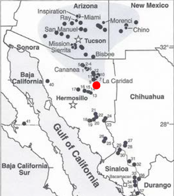
The La Sarita Project is a Cu-Ag skarn/manto/porphyry target. The project potentially lies within the same horst block as the La Caridad copper-molybdenum mine (approx. 8 Mt of copper) located 61 km to the north. The La Caridad mine is presently the largest copper producer in Mexico and the youngest dated porphyry copper system in the American Southwest at 53.6 Ma.
The author has no direct or indirect interest in this property and is solely acting as an agent.
LA SARITA PROJECT (PUERTA VERDE COPPER-SILVER PROPERTY) SKARN/MANTO/PORPHYRY
SUMMARY
The La Sarita Project is comprised of four concessions totaling 829.5 hectares ( 250K Madera H12-9) and is located 67 km south of the town of Nacozari de Garcia and 17 km east-southeast of the town of Moctezuma, northeastern Sonora, Mexico. The project is comprised of at least three superimposed hydrothermal events including manto-style tabular bodies of replacement mineralization in sedimentary rocks cut by sub-vertical chimney-style Cu-Ag mineralization. In addition, continuous porphyry-style copper oxide, copper carbonate and copper sulphate mineralization is exposed in trenches on the north-side of a major ENE long-range fault. The area collectively hosts multiple copper occurrences that cover 32 square kilometres and has the potential to host high grade underground copper-silver in chimney and replacement zones as well as a bulk mineable porphyry copper-silver deposit.
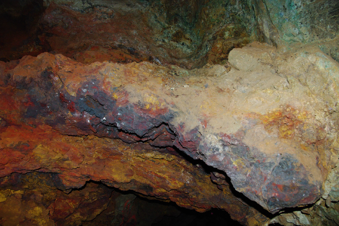
The La Sarita Puerta Verde 2 mine, as reviewed by the author, is comprised of two tunnels driven into the hill along a northeast direction collared in sediments above the basal granitoid contact in the bottom of the valley. At the Tunnel #2 entrance there is a 23 metre deep shaft. Towards the end of the tunnel a +33 metre (108 foot) vertical winze shows continuous copper mineralization to an unknown depth. The higher copper and silver grades are associated with at least 3 parallel chimney/fault breccias deposits that trend N25E to N45E/dipping 600 to 800 NW that cut the mineralized sediments at high angles. Historic workers have reported high grade copper sulphides intersected at a down-hole depth of 200 metres as well as reported copper sulphides chalcopyrite/bornite encountered at the bottom of one of the winzes in Tunnel #2 (not verified by the author).
HISTORY
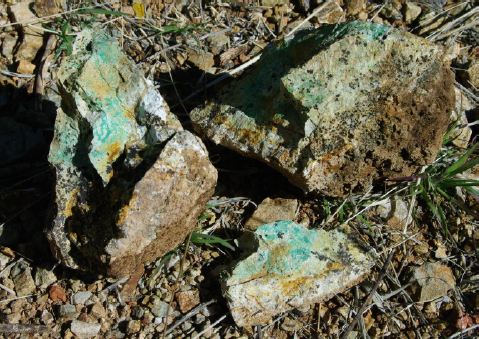
La Sarita has been the focus of historic mining by the Spaniards in shallow tunnels, pits and open cuts. The project has been in the owner’s family since 2007 and was reviewed by Simpson (1968); by J. Glass for US Borax (1970); and Willard Pye a Tucson copper consultant (1971). All reviewers strongly recommended the project. In 2008, the project was optioned by MacMillan Gold Corp. and 153 rock and 84 soil samples were taken inside and proximal to the Puerta Verde 2 mine (Tunnel 1 and Tunnel 2). In 2010, the project was optioned by Discovery Ventures Inc. In 2011, S.J. Geophysics Ltd. completed a 3D Induced Polarization Survey (22 line-km) over the southern manto/chimney target. A north/south and east-northeast/west-southwest tabular chargeability anomaly (defined by 19 to >35 milliseconds) was defined over a strike length of 1.0 km to 1.5 km (open to the southeast) to a modeled depth of 250 metres. The anomaly is coincident with a similar shaped resistivity anomaly (defined by 2500 to >12,000 ohm-m). In 2011, the owners completed six widely-spaced backhoe trenches (in 440 linear metres) up to 1500 metres north of the manto/chimney Puerta Verde 2 mine workings in an area of nested circular features exposing continuous copper oxides/copper carbonates. An estimate of the grade in the trenches, based on visual copper mineralization, ranges between 0.3 to +1.0% copper. In 2011 a NI 43-101 was completed on the property. In 2012, Discovery Ventures Inc. drilled 4 core holes (MS-01 to MS-04) into several widely-spaced targets totaling approximately 1000 metres. The drill core and the six trenches were never sampled. In 2012, Geologix Exploration Inc. requested a review of the property and conducted basic surface sampling program on some of the ENE-aligned copper occurrences.
GEOLOGY
The geology of northeastern Sonora is essentially the southern extension of the geology of southern Arizona. The La Sarita property is underlain by Late Triassic/Early Jurassic clastic continental and marine sedimentary rocks of the Barranca Group overlain by Late Jurassic to Early Cretaceous fluvio- deltaic and marine sedimentary rocks of the Bisbee Group. These older units are intruded by Late Cretaceous to early Tertiary Laramide-age granitoid rocks (diorite, monzo-diorite and granodiorite). The south-eastern part of the property is underlain by andesite/trachyte volcanics belonging to the upper member of the Lower Volcanic Complex (KsA-Tq). To the northeast Tertiary rhyolite flows and tuffs (TpaeR-TR) may be part of the upper member of the Lower Volcanic Complex.
Sediments (Bisbee Group (unit Kapa Cz-Lu) underlie the higher elevations at the Puerta Verde 2 mine and are comprised of thinly bedded locally silty limestone inter-bedded with sandstone and siltstone/shale horizons with a shallow dip to the north. The main area of porphyry-style copper-silver mineralization is underlain by biotite-diorite and gabbro/diabase; biotite-hornblende granodiorite and aplite and monzodiorite aging between 55 and 58.1 Ma. Andesite dykes and sills occur throughout the property. Steep and flat-lying faults are also present in a north-south and east-west direction. Locally sills are also common following the strike of the beds.
ALTERATION/MINERALIZATION
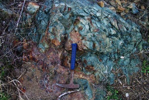
The La Sarita Property (Puerta Verde 2 Mine) in conjunction with a similar (adjoining) copper target 2.0 km to the west at Puerta Verde 1 (owned by Penoles) defines copper mineralization over an area measuring 12 km (8 mi) long and 6.4 km (4.0 mi) wide. The mineralization at the Puerta Verde 2 mine occurs in manto-style deposits in sediments, cross-cut by several sub-parallel higher grade chimney breccias. Chalcopyrite, chalcocite and bornite are the most common ore sulphide minerals in the underground as well as copper oxide (neotocite and tenorite) and copper carbonates (malachite and azurite) and copper sulphate. Many of the known mineral occurrences are coincident with gossans with goethite, jarosite, copper oxides, copper carbonates, and copper pitch. In addition, disseminate and fracture-controlled porphyry mineralization in granodiorite occurs to the north. The most common gangue minerals are goethite, jarosite, hematite, quartz, calcite and fluorite. A gossan located 800 m (0.5 mi) northwest of the Puerta Verde 2 mine measures several thousand feet in length with copper oxide in silicified and decalcified limestone. Alteration throughout the sediments includes: calc-silicate (andradite garnet) and diopside; dolomitized marble; chlorite-actinolite; and epidote.
The author took a quick look at drill-hole MS-01 drilled vertically on top of the hill above the workings. Mineralization included: bedding controlled pyrite > chalcopyrite +/- bornite related to phyllic alteration; vein/dry fractures with chalcopyrite-pyrite parallel and sub-vertical to bedding; pyrite-dominant sulfide- cemented breccias with chalcopyrite-malachite; and siderite > pyrite > garnet veins.
PROJECT HIGHLIGHTED RESULTS
| La Sarita Project Characteristics | ||||
| District Scale | Alteration | Geochemistry | Mineral Occurrences | Geophysics |
| Fault Intersections (ENE-NNE-NW) | Potassic | High Cu-Ag | Cu-Ag proximal | Borders NE-SW gravity high |
| Fault Density | Intermediate argillic | Elevated Pb + Zn + Mn | Pb-Zn-Mn distal | Borders NE-SE Cu high |
| Circular Features (nested) | Phyllic | Silver-only | N25E to N45E Faults | NE-SW fracture density |
| Radial Fault Pattern | Propylitic | Cu-only | Along ENE faults | Manto-chargeability high |
| Mineralization near contacts | Hornfels | Along NNW contacts | Manto-resistivity high | |
| Mafic Intrusions | Skarn | Borders a NE-SW Pb anomaly |
Table 1: La Sarita Characteristics (mal= malachite, az= azurite, neto=neotocite, ten= tenorite, cc=chalcocite, cp=chalcopyrite, bo=bornite) Table 2: La Sarita –Green Door 2-Tunnel 2 Sample Results
| La Sarita Green Door 2-Tunnel 2 Results | ||||
| Sample ID | Silver (g/t) | Copper in % | Interval(m ) | Comments |
| Tunnel#2A | 232.0 | 6.8 | 1.0 | 1.5m above #57 (FeOX, COX) |
| North Shaft East | 1.8 | 3.94 | east side shaft | |
| Tunnel#2B | 136.0 | 1.01 | 1.0 | 3.5m south from 33m deep winze, red oxide |
| Tunnel#2C | 310.0 | 6.84 | 1.2 | next to 47 east side of 33m deep winze |
| Tunnel#2D | 67.7 | 3.36 | 1.0 | 2 m N of #46 in sulfide zone |
| Tunnel#2E | 83.0 | 3.02 | 1.5 | 0.5m N of #59 |
| Tunnel#2F | 31.8 | 2.74 | 1.2 | 5.5m W of #47 in qtz-COX zone |
| Tunnel#2G | 459.0 | 0.3 | 1.2 | same loc at # 57 (FeOX, Malachite) |
| North Shaft West | 53.8 | 3.59 | 1.0* | west side shaft |
| 39 | 166.0 | 1.85 | 1.0* | NNE fault dips 70NW |
| 51 | 118.0 | 2.38 | 1.0* | same fault NNE fault as #39 dips 70NW |
| 52 | 158.0 | 2.49 | 1.0* | Small winze in core of fault zone |
| 53 | 107.0 | 1.74 | 1.0* | Small winze in core of fault zone |
| 55 | 157.0 | 0.5 | 1.0* | Near FW of NNE/ 70 NW dip fault |
| 59 | 312.0 | 1.44 | 1.0* | Near FW of NNE/ 70 NW dip fault |
| 60 | 61.0 | 1.29 | 1.0* | Near FW of NNE/ 70 NW dip fault |
| 71 | 76.0 | 3.12 | 1.0* | In HW of second fault NNE/ 80 NW dip fault |
| 73 | 101.5 | 2.23 | 1.0* | In FW of NNE/ 70 NW dip fault |
| La Sarita Exploration Shaft 400m north of Tunnel 2 | ||||
| East | 1.8 | 3.94 | 1.0m | 47m east of the 30m long dozer cut; az-ten |
| West | 53.8 | 3.59 | 2.0m | Far West of the 30m long dozer cut; az-ten |
Note: 1.0* implies true sample width estimated from imagery
RECOMMENDATIONS
Historic workers have suggested high grade bornite was intersected at depth in one of the winzes at the Puerta Verde 2 mine. The Puerta Verde 1 mine located a few kilometres to the west (owned by Penoles) reported high grade bornite that was mined and transported by donkey train to Moctezuma.
In 2008, porphyry-style mineralization located 400 metres north of the main mine tunnel returned 20 to 40 g/t Ag and 0.5 to 2.0% copper. The estimated copper grade (based on copper oxide and copper carbonate endowment in hand specimen) from the six trenches (440 linear metres) is estimated to be between 0.3 to 1.0 % copper.
The following work program is recommended:
- Compilation of all existing data collected to date with regional magnetic and geochemical data
- Geological mapping, prospecting and methodical rock chip sampling
- Remote sensing study to better define target areas (ASTER/structural etc.)
- Surface sampling and analysis of the six excavator trenches showing continuous copper mineralization; and underground verification sampling and mapping of the Puerta Verde 2 mine
- Definition drilling of the Puerta Verde 2 zone to determine the grade, true width and geometry of the N25 to N45E/NW-dipping higher grade (up to 6.84 % Cu and 460 g/t Ag) mineralization relative to the horizontal replacement mineralization along strike and at depth. The 3D Interpretive IP model should be integrated into the drill results during the drilling program.